Volume V ● Issue 1/2014 ● Pages 7–18
Štýřice III (Koněvova St. or Vídeňská St.) – an Epigravettian Site in Brno (Czech Republic)
Zdeňka Nerudováa*, Petr Nerudaa
aAnthropos Institute, Moravian Museum, Zelný trh 6, Brno 659 37, Czech Republic
Article info
Article history:
Received: 1 August 2014
Accepted: 16 September 2014
Key words:
Moravia
Svratka River
Epigravettian
subsistence strategies
Abstract:
The paper summarises the results of Palaeolithic research in Vídeňská (former Koněvova) Street in the city of Brno. After the first small-scale excavations carried by K. Valoch in 1972, primarily rescue excavations in recent years (2009–2014) have revealed the extent and intensity of the Palaeolithic settlement. The specific features of the locality are represented by imported raw materials, a high frequency of burins compared to other tools and a predominance of Mammuthus primigenius among the faunal remains. The settlement was earlier classified as Epigravettian which is confirmed by new radiocarbon dating. Based on the knowledge obtained in the immediate neighbourhood of the locality, it became apparent that this convenient area near the river repeatedly attracted people to build settlements in these places, in all probability specialised groups of hunters. Despite the climatically unfavourable final part of the LGT period (after a definition by Markova et al. 2013), within which the settlement at Brno-Štýřice III falls based on radiocarbon dating and malacofauna, we can take into consideration a denser settlement strategy than is usually assumed in the broader context of the Middle Danube Region.
1. Introduction
The site of Brno-Štýřice III was introduced into the relevant literature by K. Valoch, who conducted small-scale rescue excavations there (Valoch 1975). The representative collection of chipped stone industry was described as Epigravettian (Valoch 1975) because it did not include any characteristic tool types which would have made it possible to classify as Magdalenian. The assemblage was dated later (Valoch 1996; Verpoorte 2004, 262) and despite the fact that the dates were somewhat younger than expected for an Epigravettian assemblage, this fact did not provide sufficient reason to classify the finds within some other cultural unit. The next large-scale rescue excavations were carried out in 2009 and 2011–2014. They revealed the extent of settlement, defined a new site (Štýřice IIIa) and yielded a large amount of lithics and osteological material which have gradually been analysed and evaluated (Nerudová, in press, Nerudová et al. 2012). The description and categorization of the lithic industry from Brno-Štýřice III remained, however, unchanged despite a considerable increase in the quantity of archaeological material.
1.1 History of the research
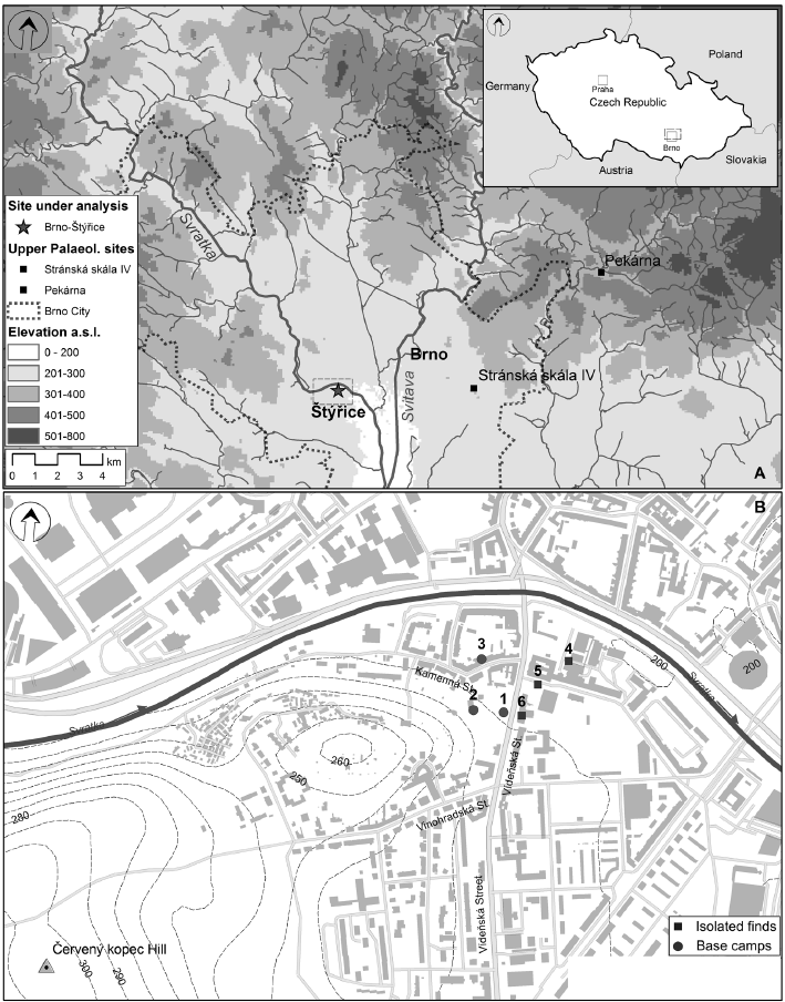
There was originally an undeveloped gap with extensive adjacent plots of land located in the city centre of Brno on Vídeňská Street between house nos. 234/16 and 241/26. It was only used for gardening up until 2009. A historical photograph from 19th April 1962 in the Brno City Archive shows only three houses remaining preserved after the old buildings were demolished. There were no houses left in 1972 when narrow trenches for underground utilities networks were dug along the border between the pavement and the gap. During the work, construction workers came across early medieval human skeletal remains, and subsequent inspection of the site also yielded a patinated chipped stone industry in situ, embedded in loess. A consequent archaeological rescue excavation over an extremely limited area was conducted here by K. Valoch in 1972 (Valoch 1975). An investor bought up large plots of land in 2009 with the aim of building a housing complex with underground parking. With the knowledge of the existence of Palaeolithic as well as prehistoric and early medieval settlements, a need arose to carry out a comprehensive large-scale rescue excavation. The Palaeolithic locality, which is also known in literature as the Koněvova (Valoch 1975) or Vídeňská Street (Wienergasse), was later renamed more exactly according to the relevant cadastre within which it falls, and given an appropriate ordinal number (Neruda, Nerudová 2010). The different naming of this locality in the relevant literature is caused by the fact that the name of the street itself has changed several times in the past – it was called Koněvova St. as of 25th September 1945, and again bears the name Vídeňská St. as of 27th February 1990 (http://encyklopedie.brna.cz/home-mmb/). Despite the historical changes in the naming, it is still the same locality although, unfortunately, completely destroyed by buildings at present.
1.2 Geographical overview and stratigraphy
The site is located in the south-west part of Brno, approximately 300 m to the south of the current bank of the Svratka River (WGS-84: 49° 11ʹ 2.5505ʹʹ N, 16° 35ʹ 41.6602ʹʹ E; S-JTSK: 1161873.78, 599243.33 – the centre of the locality). Here at an elevation of 210 m above sea level (10 m above the river) is a step in the terrain which on the west side rises up into the low but steep cliff of Lower Devonian conglomerates known as as the Červený kopec Hill with a maximum height of 311.42 m above sea level.
The Quaternary cover of the region under review is formed by an accumulation of eolian (loesses) and colluvial sediments deposited on a terrace consisting of clay fluvial gravels and sandy gravels of Quaternary age, which were detected at a depth of 202–204 m above sea level. A geological probe revealed that the sequence of Pleistocene sediments at the locality is not divided by any distinct fossil soils. Towards the superposed layers, the sequence of loesses and loessy sediments is covered by an orange silty sediment C (weakly developed soil followed by Holocene brown earth; Nerudová et al. 2012, Figure 2). Within the whole area under investigation, Holocene soil inclusive of the A and B horizons is only preserved in higher parts (i.e. at the W and SW edge of the excavated surface). In the central part of the slope only a relic of the B-horizon is preserved and in the NE and E part of the investigated area (i.e. in the lowest parts) the B-horizon is not preserved at all this being the reason why the A-horizon settled here immediately upon the Pleistocene sediments.
Archaeological finds of the Palaeolithic age were found in the lower part of the Upper Weichselian loess cover, which formed a 25 cm (approx.) thick layer of orange-brown loess-like sediment (weakly developer soil) here. This layer was almost continuously present over the entire investigated area whereby it followed the inclination of the terrain, which was quite steep in certain places. There was a relatively sharp border between the horizon with archaeological finds and underlying sediments. Although the lithic artefacts and bones were deposited in loess-like sediment, a base of the superposed chernozem horizon A sporadically intruded (e.g. the upper part of a mammoth jawbone discovered in square 9/Q).
2. Methodology
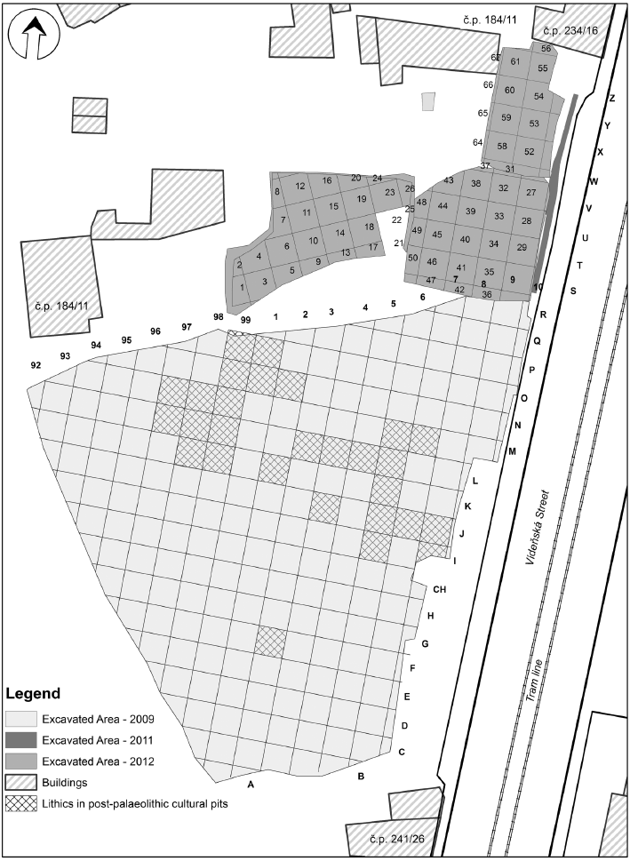
The methodology of the site excavation was affected by two main aspects. This is firstly related to the working procedure of the building construction because the area was segmented into several individual places which were available at different times. Additionally, the places were not directly related to one other. The area under investigation in 2009 was relatively extensive. Its maximum width was as much as 90 m and maximum length as much as 135 m (Figure 2). The excavation in 2011 continued just by one long pit. The rescue excavation in 2012 was carried on three individual places loosely linked to the large area from 2009. Over the last two seasons 2013 and 2014, the small remaining previously unexcavated places were investigated.
The second negative aspect of the excavation which needed to be dealt with was the fragmentation of the Palaeolithic finding horizon by medieval graves and pits. These features often cut through the archaeological layer and it was therefore sometimes possible to investigate only small relicts of the intact situation.
The only way to create a relatively precise picture of the excavated area was through the use of GIS technology. In order to fulfil the required rules for application of GIS tools, all the archaeological finds (lithics and hard animal tissues) have been measured in three coordinates and the main contextual data were recorded (classification, geological layer, number of items, and orientation of the long artefacts). Complicated archaeological situations (e.g. bone preparation or rich accumulations of lithics) were picked up as a geo-referenced blocks of sediment in situ. A detailed investigation was carried out next time in the lab using for sample washing.
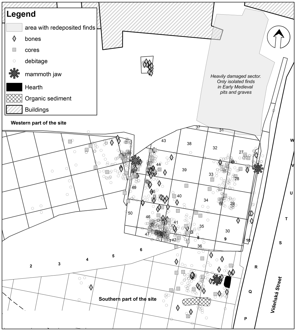
An isolated concentration of finds in situ in squares 94/M-N could be distinguished within the area excavated in 2009, preliminarily referred to as the Štýřice IIIa site (Nerudová et al. 2012, Figure 1), and the main Štýřice III site with finds accumulated particularly in squares 7-9/R-O (Figures 1 and 3). The ongoing rescue excavations in 2012 have revealed that the occupation layer continued in the northern and western directions (only K. Valoch dug partial trenches here on those areas which were not excavated earlier, Figure 1). Whereas Palaeolithic finds clearly fade out in a western direction, their number rose towards the north where they formed certain concentrations (Figure 3). A prehistoric settlement (settlement pits, early medieval graves, and Romanesque rotunda) and recent intrusions (house cellars, water piping etc.) also became more frequent in this area at the same time. All these post-Palaeolithic intrusions disturbed the shallowly deposited layer with Palaeolithic artefacts and bones, which was therefore completely destroyed in certain places (Figure 3), whereas elsewhere the Palaeolithic finds found their way into the secondary backfill of later features (for example a mammoth molar in the backfill of a feature containing Moravian Painted Ware). The bottoms of a number of grave pits were sunk as deep as in the Palaeolithic layer. The base of the foundation slab of the Romanesque rotunda exposed in 2012 was situated stratigraphically only 10 cm above an accumulation of chipped lithics found in situ.
The possible spread of the settlement towards the east is no longer identifiable because a road and a pavement pass through this area. Thus, even though the area under investigation is relatively large, we are able to reconstruct only a small part of the supposed settlement. We are not be able to identify the northern edge of the site, which is hidden below house no. 16.
3. Results
The lithic industry from the Štýřice III site was gradually obtained by excavations from 1972–2011. A total of 1111 pieces of chipped stone industry were documented together with a total of 1563 pieces of osteological material. Malacofaunal remains and microscopic pieces of charcoal were found during floatation. K. Valoch mentions dye fragments, which were not found within the scope of the new excavations, in his findings. They are in all probability weathering products of local red conglomerates from the massif of Červený kopec Hill.
3.1 Chipped stone industry
The site under review yielded all technological groups of the chipped stone industry beginning from the preparation of raw material and the forming of cores (primary decortication) over exploitation (extraction of the final blanks accompanied by preparation and rejuvenation) through to remnants and fragments of debitage and cores (Table 1).
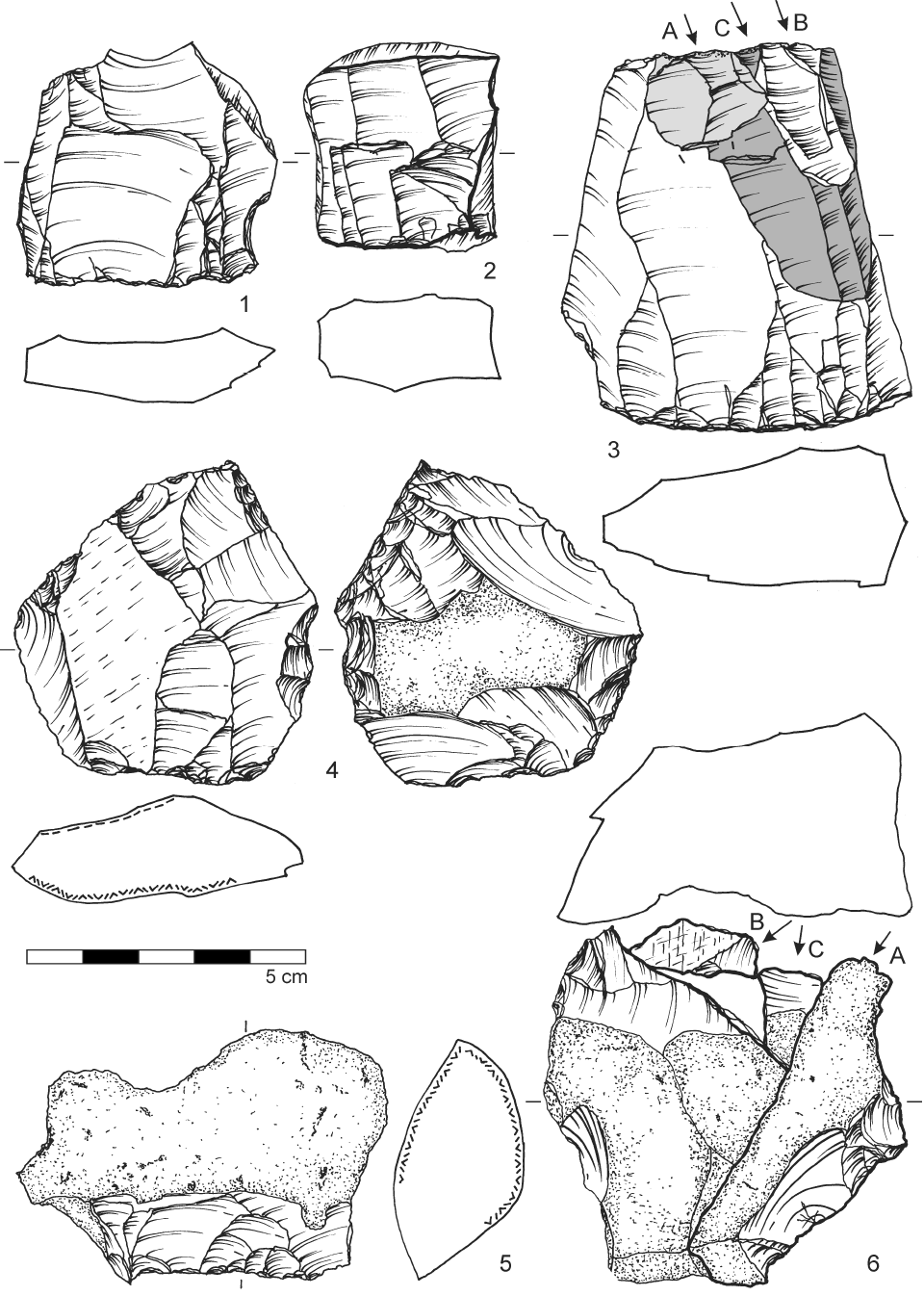
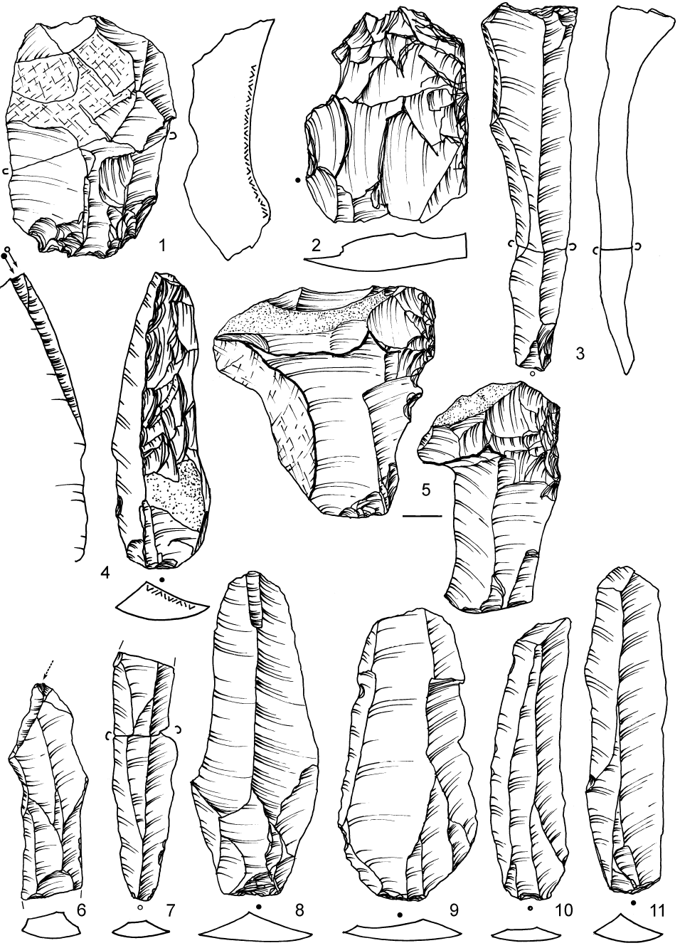
The knapping technique is focused on single-platform cores with the aim of obtaining regular blades (unidirectional reduction strategy), as is evident from parallel scars preserved on several cores (cf. Figure 4: 3 and 5: 6–11). During exploitation, the transversal and longitudinal convexity of the knapping surface was continuously maintained, as is exemplified for example by a core refitting including a sequence of tiny chips rejuvenating the distal (opposite) part of the knapping surface. The cores show evidence of modifications on their lateral and distal parts, and preparation of their back (Figure 4: 4). Even though preparation by an unilateral crested blade is demonstrable (Figure 4: 6), the reduction sequence was usually initiated by numerous detachments from the core’s lateral side (Figure 5: 5).
The collection is typical for intensively exploited cores, whose exhausted remnants already exhibit flake scars. They also often show modifications such as a change in the direction of reduction (Figure 4: 5). The original dimensions of the cores and raw material can be derived, for example, from the preserved rejuvenation of striking platforms (Figure 5: 1, 2) or the detachments of the distal part of the core (outrepassé – plunging termination; Figure 5: 3; Table 1).
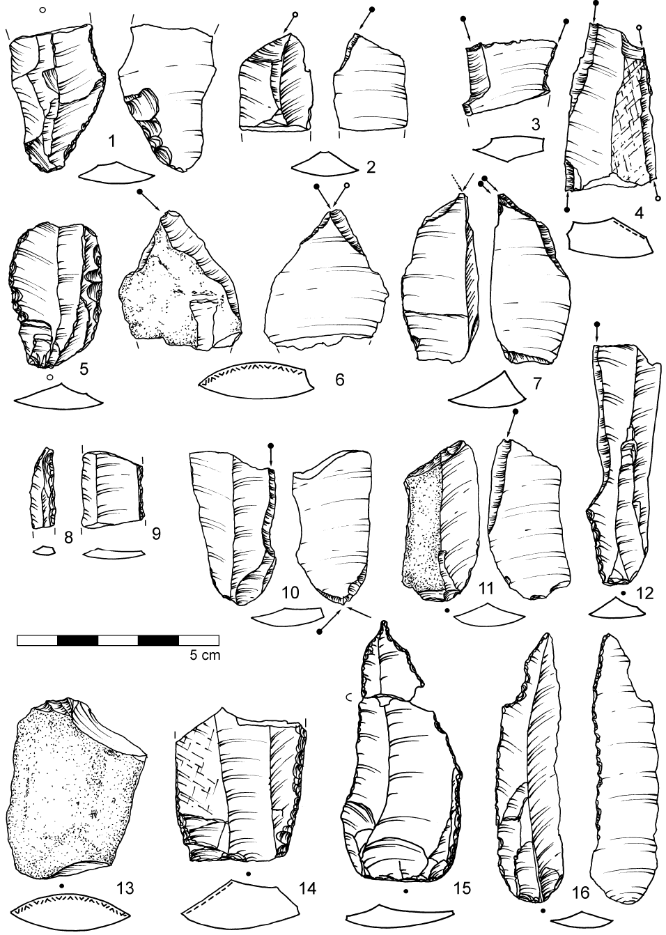
Based on certain refitted artefacts, it seems that despite the evident blade-like character of the industry, a certain part of the final blanks or tools made on these blanks were carried away from the site. The collection of tools, which does not include the finds from 2012 and 2014, contains a mere 56 specimens (Table 2), which is an extremely low share. The variety of tools is so far very specific and includes both intentional tools (deliberately modified by retouch) and artefacts with macroscopically determinable use-wear (small discontinuous retouching of edges which emerged secondarily from working with an artefact). The dominant group of tools consists of burins, the proportion of which, after taking into account new excavations, will be much higher than the current 41% (Figures 5 and 6). An almost equal number of dihedral burins (Figure 6: 6) and burins on retouched truncation (Figure 6: 11) can be found among them, as well as multiple burins (Figure 6: 2, 3), multiple burins on retouched truncation or oblique burins on retouched truncation. Burins are accompanied by numerous burin spalls (cf. Table 1) documenting their reutilisation directly on site, which is demonstrated by their refitting with burins (Nerudová et al. 2012, Figure 9: 11, 13).
Lateral or bilateral retouches with a 32% share (Figure 6: 9, 14) and various sorts of use-wear (Figure 6: 1) follow after burins. The third most significant group of tools are the backed bladelets (6 pieces in total, i.e. 10.7%; Figure 6: 8). All the other tool types in the assemblage from Štýřice III are thus far represented by one specimen each – e.g. an atypical end-scraper (Figure 6: 13), a denticulate, an artefact reminiscent of a splintered piece, or borer (Figure 6: 15) which is composed of two parts where the character of the breakage indicates some dynamic activity.
3.2 Raw materials
The range of raw materials used within the site is quite varied and indicates contacts all over Moravia (Table 3). The highest proportion is erratic flint (56.5%) which was brought to the site from secondary sources in Northern Moravia and Silesia, from a distance of at least 140 km. It was dragged to the area by a continental glacier (Přichystal 2009). Thereafter it follows that the Olomučany-type cherts (23.5%) whose primary source is situated in the central part of the Moravian Karst near the eponymous village about 17 km distance from Brno. These cherts were widely used especially at the end of Upper Palaeolithic, when they are known from numerous Magdalenian and Epimagdalenian cave sites of the Moravian Karst (Přichystal 2009). Another important raw material was spongolite (Cretaceous chert, 10.7%), primarily occurring in the northern outcrops of the town of Letovice (approx. 40 km north of Brno). Spongolites were secondarily transported to the south, however, by the Svitava River, and may consequently be found in Pleistocene sandy gravel terraces in Brno, or even much further away, for example, as far as below the Pavlov Hills (Přichystal 2009). The remainder of the raw materials remains undetermined (0.72%) or their origin could not be exactly identified (1.26%). Several artefacts exhibited burn marks (3%). The excavation in 2012 also yielded radiolarite, flint of unknown origin or fine-grained quartzite macroscopically reminiscent of porcellanite. Detailed determination of these raw materials will be the topic of further analyses but it is already evident that there was a significant difference in the raw materials economy between the Štýřice III and IIIa sites, that can be support with a dominant orientation on the Olomučany-type chert at the Štýřice III site.
Interesting in terms of methodology is the general taphonomy of the lithic industry, whose one part is patinated at various intensity (mainly erratic flint, Krumlovský les-type chert, spongolite), whereas the other part made of the Olomučany-type chert provides an extremely “fresh” impression. Since the patinated and non-patinated artefacts have been found together within the same layer and in the same context, whereupon they can be considered contemporary, their different state of preservation is probably due to the properties of the individual rocks used. In the case of surface survey, the non-patinated artefacts would be probably classified as post-Palaeolithic.
3.3 Osteological material
Depositional conditions at the locality (see the chapter Stratigraphy) immediately underlying the Holocene soil have caused the majority of the osteological material to almost completely corrode, making it disintegrate when taken out of the earth. These post-depositional processes also affected the bones with relatively thick compact. The taphonomy of the surface is very difficult to perform and any anthropic impacts on hard animal tissues cannot be studied, neither can those associated with alimentary practices nor the non-alimentary ones. Among the material preserved were 1563 fragments of animal bones, with 82.5% of them under 20 mm in size. This is why 68.4% of all the fragments remained undetermined in terms of taxonomy and anatomy (Nerudová et al. 2012). The variety of determined taxa at the locality is as follows:
The most interesting osteological find from the excavation in 2009 is a not entirely complete lower jaw of a woolly mammoth, which based on an analysis of the preserved molars in all probability comes from an individual older than twenty years of age. A second mammoth jaw, namely the symphysis of the left and right hemimandible, was discovered in 2011 (Nerudová et al. 2012). Fragments of mammoth lamellae were continuously found all over the excavation area. The spectrum of species will certainly be supplemented with new taxa after an evaluation of the material from 2012. Preliminarily the incisors of wolf (Canis lupus) and fox (Vulpes sp.; pers. com. M. Roblíčková) can be mentioned.
3.4 Charcoal
Numerous small and large burnt organic fragments were taken from the surface of a hearth detected by K. Valoch and then again by the excavation in 2009 (Figure 3). An anthracological analysis revealed that it is not only charcoal but fragments of unidentifiable burnt animal bones. Among them, however, was a single fragment of a microscopic piece of charcoal classified as Larix/Picea. The preliminary results of the determination of the charcoal pieces obtained by the excavation in 2012 indicate a humid environment with incidence of larch, willow and birch (pers. com. J. Novák, 17th May 2013).
3.5 Mollusca
Malacofaunal finds of Pupilla loessica, Vallonia excentrica and Helicopsis striata also come from the hearth. According to a determination by L. Juřičková, these molluscs are typical representatives of loess steppe, at the full glacial period, because Pupilla loessica disappears by the late glacial. Other finds of the same faunal association were also found during the following excavations. With regard to the chemical composition of the soil affected by post-depositional processes, the shells were always only preserved in sediment in the immediate neighbourhood of large bone fragments or a hearth respectively. These places are more calcareous than the surrounding area, which enabled the preservation of shells (pers. com. M. Hejcman, 29th January 2013).
3.6 Dating
The industry from Brno-Štýřice III was classified by K. Valoch as Epigravettian with a somewhat younger radiocarbon dating (Table 4) falling within a period in which the Magdalenian had already appeared in Central Europe, as is documented, for example, by the new dates from Maszycka Cave (Kozłowski et al. 2013). Additional samples for dating were taken by A. Verpoorte in 2001. A very similar date was obtained from the bone collagen (Verpoorte 2004). The second sample of a burnt remnant yielded two dates (GrA-19572 and GrA-20137), which, however, according to the laboratory comments, are not reliable because burnt remnants (in fact the apatite fraction of the burnt remnant which was not exposed to a temperature higher than 600°C) usually provide “bad results” (pers. com. A. Verpoorte, 31st January 2012). In order to determine a more exact chronostratigraphical position for the Brno-Štýřice III finds, several samples from the excavation in 2009 were sent for radiocarbon dating. From the four samples submitted thus far, only a single date from a mammoth molar was obtained: OxA-26961: 15625±75 BP (18780±90 cal BP). The other samples contained too little collagen and failed due to a low yield.
4. Discussion
Calibration of the new date from Brno-Štýřice III as well as of a second date obtained from the excavation by P. Škrdla in the area of a nearby hospital (Table 5) allows us to date the settlement of this locality to a time before 18,000 cal BP, that is to the LGT period (after a chronostratigraphical division by Markova et al. 2013, Figure 1). It is generally thought that the decrease in the evidence of settlement at the LGM was caused by climatic changes or by considerable worsening of the climate respectively (Banks et al. 2008).
Climatic conditions at the end of the last glacial, however, could not be the main reason why the population density in Moravian territory became reduced because the preceding Gravettian population had dealt with first significative cooling (LLGM; cf. Clark et al. 2009) successfully. In addition, new excavations in recent years have shown that the delimited time span is only seemingly empty. The first discovered settlements fall chronologically into the aforesaid interval. In terms of stratigraphy, however, finds from these localities are situated in the uppermost level of the Upper Weichselian loess cover which is often secondarily affected by Holocene pedogenesis (Neruda et al. 2009; Neruda, Nerudová 2008; Nerudová et al. 2012). Moreover, the possibility of discovering such localities is also made less likely by recent human activities, particularly if localities in towns or their outskirts are involved.
A second generally assumed characteristic of this period is that the Central European area witnessed a decrease in mammoth. The new-coming Magdalenian people no longer hunted them and their mammoth depictions have been interpreted as reminiscence. Sporadic finds of mammoth bones in the context of Magdalenian settlements were classified as secondary gathering of carcasses. In this regard not only the knowledge obtained from the excavated site of Brno-Štýřice III is of interest, but also the new information concerning the dating of mammoth bones from archaeological contexts. It turns out that, for example, mammoths that were found at the site of Dzierżysław in Southern Poland are dated to 12.5 ka 14C BP (Nadachowski et al. 2011). Their occurrence is interpreted as a response to the reappearance of cryophilic and open vegetation at the end of the Pleniglacial prior to the onset of the Bølling – Allerød warm period. The final decline of mammoths is supposed to have taken place on the territory of Southern Poland (Nadachowski et al. 2011, 191). As far as Brno-Štýřice III is concerned, it is the neighbourhood of a large river flowing in the supposed corridor of migrating herds in the Middle Danube Region, which provided nourishment for animals and for those who hunted them. The δ18O isotope analyses of dentine and enamel have shown that the values of the local glacial palaeoenvironment obtained correspond to oxygen isotope levels in several East Central European locations (Kovács et al. 2012). Radiocarbon dating together with scientific analyses make it possible to establish a chronological link between the settlement at Brno-Štýřice III and the LGT period. Based on the analysis of the chipped stone industry, the finds can be associated with the Epigravettian culture because until now no culturally significant types were found which would link this industry with the Magdalenian.
One of the important features which should be focused on in the future, is the unequivocal cultural classification of the Brno-Štýřice III assemblage because the site is dated to a period (roughly 15 ka 14C BP.) when Magdalenian hunters penetrated Central Europe. There are no Magdalenian sites in Moravia which are contemporaneous with such sites as Maszycka Cave in Poland for instance (Kozłowski et al. 2013). The oldest Magdalenian settlement of Moravia is documented by finds from Balcarka Cave in the Moravian Karst dated to 13.9 ka 14C BP. (Neruda 2010, Table 1).
The dominant tool-type of the Brno-Štýřice III assemblage is a burin in several variants (41%; Table 2). Backed blades and bladelets as the main part of the Epigravettian are only represented by 10.7% (Table 2). This different composition should not be taken as clear evidence since different cultural classification analyses of Epigravettian lithics reveal the differentiation among the sites. Typological differences perhaps reflect the functional variability of the sites. Such variability can even be noted in the same region. Sites with an abundance of short end scrapers have been documented in Croatia (such a type is missing in Brno-Štýřice III). Microgravettes and backed bladelets predominate in other localities (Šandalja II, Layers B/s and C/d, Vešanska Péć in Croatia). Burins, end scrapers and backed bladelets are typical for Pupićina Cave in Istria, short end scrapers and geometric microliths in Vela Spila or Kopačina Caves (Croatia), short end scrapers in Crvena Stijena (Montenegro) or Romanelli (Italy), or backed tools in Paglici Cave of Riparo in Italy (Janković et al. 2012, 119). The best analogy for the Brno-Štýřice III assemblage is represented by the Stadice Open-air site in Bohemia where burins predominate over end scrapers, which are practically missing. Backed points and backed bladelets are relatively rare (Vencl, Oliva 2012, 51).
A new approach to the debate about the cultural classification of the Brno-Štýřice III assemblage is based on an analysis of striking platform remnants of blades from the Moravian Magdalenian, Gravettian and Epigravettian assemblages. Statistical analyses of both metric and morphological data reveal a distinct separation of the Brno-Štýřice III site from the Magdalenian items from Pekárna and Ochozská Caves (Mozola 2013, Graph 8a and 57). For this reason we assume that the lithic assemblage from Brno-Štýřice III belongs to the Epigravettian tradition.
5. Conclusion
A complex of several sites in the vicinity of the Brno city centre was recently discovered in the cadastral territory of Štýřice. Apart from abundant chipped stone industry of a specific character (various burins and backed bladelets) a considerable amount of osteological material was also found, surprisingly dominated by mammoth. The knowledge obtained enables a comparison, for example, with the sites of Mezhirich in the Ukraine (Marquer et al. 2012), Stránská skála IV (Svoboda 1991), Stadice in NW Bohemia (Vencl, Oliva 2012) or Grubgraben in Austria (Neugebauer-Maresch et al. 2008). The site at Brno-Štýřice III is interpreted as Epigravettian hunting camp focused on mammoth processing.
Acknowledgements
This article was financially supported by the Ministry of Culture of the Czech Republic by the institutional financing of long-term conceptual development of the research institution (the Moravian Museum, MK 000094862).
The authors would like to dedicate this article to K. Valoch in honour of the 60th anniversary of his active work at the Anthropos Institute of the Moravian Museum where he was employed as of 1st December 1952. Although, he sadly did not live long enough to see the article published, he was the first to be informed about all the news. He not only visited the excavations in 2012 but also regularly went to the laboratory and supervised the cleaning of the artefacts.
References
BANKS, W., E., D’ERRICO, F., PETERSONC, T., VANHAEREND, M., KAGEYAMAE, M., SEPULCHREE, P., RAMSTEINE, G., JOSTF, A., LUNTG, D. 2008: Human ecological niches and ranges during the LGM in Europe derived from an application of eco-cultural niche modeling. Journal of Archaeological Science 35, 481–491.
CLARK P. U., DYKE A. S., SHAKUN J. D., CARLSON A. E., CLARK J., WOHLFARTH B., MITROVICA J. X., HOSTETLER S. W., MCCABE A. M., 2009: The Last Glacial Maximum. Science 325, 5941: 710–714.
JANKOVIĆ, I., AHERN, J., C., M., KARAVANIĆ, I., STOCKTON, T., SMITH, F., H. 2012: Epigravettian Human Remains and Artifacts from Šandalja II, Istria, Croatia. PaleoAnthropology, 87–122.
KOVÁCS, J., MORAVCOVÁ, M., ÚJVÁRI, G., PINTÉR, A., G. 2012: Reconstructing the paleoenvironment of East Central Europe in the Late Pleistocene using the oxygen and carbon isotopic signal of tooth in large mammal remains. Quaternary International 276–277, 145–154.
KOZŁOWSKI, S., K., POŁTOWICZ-BOBAK, M., BOBAK, D., TERBERGER, T. 2013: New information from Maszycka Cave and the Late Glacial recolonisation of Central Europe. Quaternary International 272–273, 288–296.
MARKOVA, A., K.,PUZACHENKO, A., Y., VAN KOLFSCHOTEN, T., VAN DER PLICHT, J., PONOMAREV, D., V. 2013: New data on changes in the European distribution of the mammoth and the woolly rhinoceros during the second half of the Late Pleistocene and the early Holocene. Quaternary International 292, 4–14.
MARQUER, L., LEBRETON, V., OTTO, T., VALLADAS, H., HAESAERTS, P., MESSAGER, E., NUZHNYI, D., PÉAN, S. 2012: Charcoal scarcity in Epigravettian settlements with mammoth bone dwellings: the taphonomic evidence from Mezhyrich (Ukraine). Journal of Archaeological Science 39, 109–120.
MOZOLA, J. 2013: Rozlišení mladopaleolitických kultur na podkladě technologické analýzy sbíjení kamenných polotovarů. Unpublished bachelor thesis. Deposited: Faculty of Arts, Masaryk University, Brno.
NADACHOWSKI, A., LIPECKI, G., WOJTAL, P., MIĘKINA, B. 2011: Radiocarbon chronology of woolly mammoth (Mammuthus primigenius) from Poland. Quaternary International 245, 186–192.
NERUDA, P. 2010: Chronologická pozice paleolitického osídlení jeskyně Balcarky ve středoevropském kontextu. In: Nerudová, Z. (Ed.): Jeskyně Balcarka v Moravském krasu. Anthropos 31 (N.S. 23), 83–95, Brno.
NERUDA, P., NERUDOVÁ, Z. 2008: Loštice I – výzkum nové magdalénienské stanice na střední Moravě. Archeologické rozhledy 60, 509–528.
NERUDA, P., NERUDOVÁ, Z. 2010: Brno (k.ú. Štýřice, okr. Brno-město). Přehled výzkumů 51, 275–278.
NERUDA, P., NERUDOVÁ, Z., ČULÍKOVÁ, V. 2009: Loštice I – Kozí vrch. Magdalénienská stanice v Horním Pomoraví. Acta Musei Moraviae – Scientiae sociales 94, 39–64.
NERUDOVÁ, Z. in press: On site settlement activities: the example of the Epigravettian site of Brno-Štýřice III (Czech Republic). Anthropologie.
NERUDOVÁ, Z., NERUDA, P., LISÁ, L., ROBLÍČKOVÁ, M. 2012: Záchranný výzkum mladopaleolitických lokalit v Brně-Štýřicích v kontextu osídlení Brněnska. Archeologické rozhledy 64, 591–627.
NEUGEBAUER-MARESCH, C., BACHNER, M., TUZAR, J., M. 2008: Kammern-Grubgraben. Wiss. Mitt. Niederösterr. Landesmuseum, St. Pölten 19, 109–118.
PŘICHYSTAL, A. 2009: Kamenné suroviny v pravěku východní části střední Evropy. Masarykova univerzita, Brno.
SVOBODA, J. 1991: Stránská skála. Výsledky výzkumu v letech 1985–1987. Památky archeologické 82, 5–47.
SVOBODA, J., FIŠÁKOVÁ, M. 1999: Velké Pavlovice (okr. Břeclav). Přehled výzkumů 40, 184–186.
ŠKRDLA, P., NÝVLTOVÁ FIŠÁKOVÁ, M., SEDLÁČKOVÁ, L., ZAPLETALOVÁ, D. 2005: Brno (k. ú. Štýřice, okr. Brno-město). Přehled výzkumů 46, 173–177.
VALOCH, K. 1975: Paleolitická stanice v Koněvově ulici v Brně. Archeologické rozhledy 27, 3–17.
VALOCH, K. 1993: V záři ohňů nejstarších lovců. In: Podborský, V. (Ed.): Pravěké dějiny Moravy, 11–70, Brno.
VENCL, S., OLIVA, M. 2012: Stadice – an Epigravettian site with non-utilitarian structures in NW Bohemia. In: Hugo Obermaier-Gesellschaft, 54. Jahrestagung in Toulouse, 10.–14. April 2012, 51–52, Toulouse.
VERPOORTE, A. 2004: Eastern Central Europe during the Pleniglacial. Antiquity 78, 257–266.
*Corresponding author. E-mail: znerudova@mzm.cz
0 300 m
Figure 1. Localization of the discussed sites in Brno: 1 – Štýřice III; 2 – Štýřice IIIa, 3 – Kamenná St.; 4 – Vídeňská St. Hospital; 5 – Polní St.; 6 – Vídeňská St.; House No. 25 (drawing by P. Neruda).
Figure 2. Brno-Štýřice III. Excavated areas 2009–2012. The documentation of the following excavation in the years 2013 and 2014 is in progress (GIS reconstruction by P. Neruda).
Figure 3. Brno-Štýřice III. Detail of the spatial find distribution (GIS reconstruction by P. Neruda).
Figure 4. Brno-Štýřice III. Selected cores, excavation 1972 (6) and 2009: 1, 4 – erratic flint, all others – Olomučany type chert; 3 – refitting of a unidirectional blade core and a sequence of three rejuvenation flakes on the opposite platform; 6 – refitting of a precore with crested blade and preparation flakes (drawing by Z. Nerudová).
Figure 5. Brno-Štýřice III. Selected artefacts: 1, 4–6 – erratic flint, all others Olomučany type chert; 2 – excavation 1972; 4 – excavation 2011; others – excavation 2009 (drawing by Z. Nerudová).
Figure 6. Brno-Štýřice III. Selected tools: 1–2, 9, 11, 14 – erratic silisite; 3–5, 7, 12 – Olomučany type chert; 6, 13 – Krumlovský les type chert; 8 – spongolite; 10 – burnt artefact; 15 – excavation 2011; 16 – excavation 1972; all others – excavation 2009 (drawing by Z. Nerudová).
0 30 m
0 15 m
Table 1. Brno-Štýřice III. An overview of the lithic industry (in pcs).
|
Lithic inventory |
Flake |
Blade |
Σ |
|
first blank |
4 |
0 |
4 |
|
cortical blank |
3 |
1 |
4 |
|
blank with major part of cortex |
13 |
2 |
15 |
|
crested blank – 1 core side |
3 |
11 |
14 |
|
secondary crested blank |
2 |
0 |
2 |
|
trimming blank |
121 |
22 |
143 |
|
blank with lateral cortex |
14 |
28 |
42 |
|
final blank |
89 |
119 |
208 |
|
blank with lateral part of core |
28 |
10 |
38 |
|
flake rejuvenated striking platorm |
3 |
0 |
3 |
|
blank reuvenated of exploited surface |
9 |
3 |
12 |
|
reparation of crested blade |
6 |
2 |
8 |
|
outrepassé |
3 |
9 |
12 |
|
fragments |
442 |
33 |
475 |
|
burin spall |
3 |
33 |
36 |
|
splinters |
37 |
1 |
38 |
|
Σ |
780 |
274 |
1054 |
|
raw material fragment |
4 |
||
|
retoucher |
1 |
||
|
abrader |
2 |
||
|
manuport? |
7 |
||
|
prepared core |
4 |
||
|
precore |
3 |
||
|
exploited blade core |
12 |
||
|
exploited flake core |
18 |
||
|
core rest |
2 |
||
|
core fragment |
4 |
||
|
Σ |
57 |
Table 2. Brno-Štýřice III. Tool types.
|
Tools |
pc |
% |
|
atypical end scraper |
1 |
1.78 |
|
burin on retouched truncation |
7 |
41.1 |
|
dihedral burin |
6 |
|
|
burin multiple |
2 |
|
|
burin multiple on retouched truncation |
2 |
|
|
burin fragment |
2 |
|
|
burin on retouched truncation oblique |
3 |
|
|
burin atyp. |
1 |
|
|
borer |
1 |
1.78 |
|
backed bladellet |
6 |
10.72 |
|
denticulate |
1 |
1.78 |
|
notch on dorsal face |
1 |
1.78 |
|
splintered tool? |
1 |
1.78 |
|
truncated blade |
1 |
5.36 |
|
truncated piece oblique |
2 |
|
|
lateral retouch |
3 |
8.93 |
|
bilateral retouch |
2 |
|
|
lateral use-wear |
13 |
23.21 |
|
point |
1 |
1.78 |
|
Σ |
56 |
100.0 |
Table 3. Brno-Štýřice III. Raw material composition. SGS – erratic silisite, OL – Olomučany type chert, KL – Krumlovský les type chert, SP – spongolite, MJR – undetermined different types of chert, UNDET – undetermined.
|
|
Σ |
% |
|
OL |
281 |
25.29 |
|
KR |
27 |
2.43 |
|
SGS |
628 |
56.53 |
|
SP |
119 |
10.71 |
|
MJR |
14 |
1.26 |
|
BURNT |
8 |
0.72 |
|
UNDET |
34 |
3.06 |
|
Σ |
1,111 |
100.00 |
Table 4. Radiocarbon dating of Brno-Štýřice III (Vídeňská St.). Notice: * This is the same sample.
|
Lub number |
14C BP |
Type of sample |
Source |
|
GrN-9350 |
14450±90 |
bone* |
(Valoch 1993) |
|
GrA-20002 |
14820±120 |
bone colagen* |
(Verpoorte 2004) |
|
OxA-26961 |
15625±75 |
mammoth molar |
excavation 2009 |
Table 5. Radiocarbon dating of Epigravettian sites in the surroundings.
|
Site |
Lab number |
14C BP |
Type of sample |
Source |
|
Kamenná St. |
OxA-24105 |
14235±60 |
mammoth tusk |
(Nerudová et al. 2012) |
|
Hospital grounds – Vídeňská St. |
GdA-459 |
15 650±70 |
mammoth molar |
(Škrdla et al. 2005) |
|
Stránská skála IV |
GrN-13945 |
18220±120 |
bone |
(Svoboda 1991) |
|
Stránská skála IV |
GrN-14351 |
17740±90 |
bone |
(Svoboda 1991) |
|
Velké Pavlovice |
GrN-16139 |
14460±230 |
horse bone |
(Svoboda – Fišáková 1999) |
0 5 cm
0 5 cm
0 5 cm