0 30 m
Volume V ● Issue 1/2014 ● Pages 31–47
The Use of Environmental Methods for Studying the Fortification, Economic System and Natural Environment of a Hillfort from the Beginning of the Middle Bronze Age at Vrcovice, Czech Republic
Daniel Hláseka*, Petra Houfkováb, Lenka Kovačikováb, Antonín Majerc, Jan Novákb, Jaroslav Pavelkaa, Tomáš Beštab, Tereza Šálkováb
aDepartment of Archaeology, Faculty of Philosophy and Arts, University of West Bohemia in Pilsen, Sedláčkova 15, 306 14 Pilsen, Czech Republic
bLaboratory of Archaeobotany and Palaeoecology, Faculty of Science, University of South Bohemia; Branišovská 31, 370 05 České Budějovice, Czech Republic
cPalackého 62, 387 01 Volyně, Czech Republic
Article info
Article history:
Received: 20 January 2014
Accepted: 4 August 2014
Key words:
fortification
Middle Bronze Age
plant macro-remains
anthracology
palynology
archaeozoology
food detection by antibodies
phosphate analysis
magnetic susceptibility
remanent magnetization
Abstract
This contribution summarises the most important results of the environmental methods applied in a study of a significant hillfort at Vrcovice (South Bohemia) from the beginning of the Middle Bronze Age. Attention was already paid to the environmental attributes of the archaeological sources (e.g. phosphate analysis) during systematic excavations over the years 1963–1966. Important findings emerged out of archaeo-environmental research conducted here in 2013, during which a number of methods were applied to study the economic system (archaeozoology, food detection by antibodies, plant macro-remains), the natural environment (anthracology, palynology) and the reconstruction of the original form of fortification (magnetic susceptibility, remanent magnetization). Samples were also obtained for two radiocarbon dates. The hillfort at Vrcovice ranks among the most important resources for the study of fortified settlements from the Bronze Age in Bohemia due to the holistic approach taken.
1. Introduction
Enclosures of hilltop positions are a typical phenomenon of the first half of the second millennium BC in a substantial part of Europe. There has been a long-term tendency on the part of archaeological research to only focus on finding links between central European fortified settlements and those in the Aegean region, while other issues did not receive sufficient attention (Jaeger 2011). Research into the economic system at various fortified settlements has only been marginal and completely non-systematic. This situation is beginning to change, however, (for example Müller et al. 2010; Jelínek et al. 2013). The fortified settlement of Vrcovice is often referred to as direct evidence of an influence from the Aegean region (Hásek 1975; Bouzek 2009, but compare with Alušík 2012).
The fortified settlement of Vrcovice was systematically excavated over the period of 1963–1966 by A. Beneš (e.g. Beneš 1966). Chronological and typological analyses of artifacts from this research and other more detailed studies imply that the site was only used during one, in all probability extremely short, period at the beginning of the Middle Bronze Age (ca the 16th century BC). This fact allows for the application of various environmental methods for clearly dated archaeological contexts with a minor risk of contamination with materials from other periods.
Research conducted in 2013 only minimally disturbed the intact surface of the fortification. The aim was to study the original layout of the inner rampart, the economic system and the natural environment during the existence of the settlement. These aspects were investigated as part of thorough research at this site (Hlásek et al. in press). This study summarises the applied scientific methods and achieved results which helped reconstruct a more accurate picture of the Vrcovice settlement.
1.1 Description of the fortified settlement
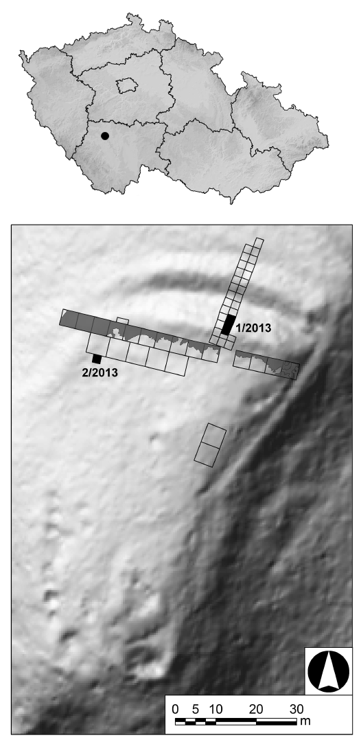
The Vrcovice site is situated on a promontory on the right bank of the Otava River approximately 3.5 km upstream from the town of Písek. The promontory is defined by the Otava River from the west and south and by a small creek from the east. The remains of the 25 m wide fortification system, formed by two walls and a ditch between them, are found in the north. The enclosed area of the promontory occupies approximately 0.55 hectares (Figure 1). The rocky bedrock, exposed on the southern slope of the promontory, is formed by weakly to moderately migmatized pearl gneisses with inserts of biotite paragneisses and migmatite with a predominating ortho-component (Fišera, undated manuscript). Cambisols are most prominent in the area (Tomášek 2000). The physic-chemical characteristics of these soils negatively affected the preservation of the unburned osteological material. The area of the fortified settlement and its surrounding area is covered by pine forest, with the predominant tree species being apart from pine (Pinus sylvatica), oak (Quercus petraea) and hazel (Corylus avellana).
2. Methods
2.1 Field research
Systematic excavation conducted by Antonín Beneš in 1963–1966 focused on the area of the internal base of the inner wall and cross-section through the fortification. An area of 515 m2 was unearthed in total (Figure 1). A number of the bones analysed in this study were obtained from here. The cultural layer of the inner space of the fortification also provided ceramic fragments with macroscopically visible potential accretions; these were subsequently analysed by the food detection method using food antibodies. Phosphate analysis was also performed in the inner area in the foregrounds of the outer wall over a network of 5×5 m in 1963.
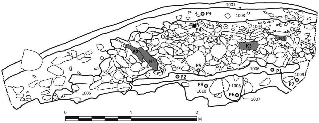
Two trenches were excavated during the excavation carried out in 2013. The first trench 1/2013 performed the function of revision research into the cross-section through the inner wall initially uncovered in 1964 (Figure 2, 14). Trench 2/2013 was placed into the settlement area (Figure 1). It followed the partially exposed Feature I from 1965, which contained over-burned bones and a fragment of a bronze object. The preservation of a higher concentration of organic material in the rest of this feature was consequently assumed. Sample sediments were collected for bioarchaeological analyses from both trenches (Table 1). Total of 675 l of the sediment were floated; subsequently both the floating component (flot) and the non-floating residuum were analysed (for a method description see Šálková 2011). Samples for pollen analysis were collected from the individual stratigraphic layers. Geoarchaeological methods were consequently used in the intact situations in the terrain for measurements of magnetic susceptibility and remanent magnetization.
Five samples with a total volume of 34 l were collected from revision trench 1/2013 from the intact profile of the cross section through the rampart from the individual stratigraphic layers with the aim of obtaining organic material for radiocarbon dating using the AMS method and for identifying the woods used for construction of the rampart. The samples for the pollen analysis were taken from the individual stratigraphic layers (Figure 2) with the objective of reconstructing vegetation composition in the wider surroundings of the settlement at the time of the settlement construction. The volume magnetic susceptibility was measured on the intact profile of the wall cross-section. Samples for remanent magnetization from the rampart sectional profile were measured in situ with a geological compass for orientation to the cardinal points and the gradient, collected and processed in a laboratory. The aim of the measurement was to reconstruct the rampart layout (e.g. the orientation of the front stone partition at the time of its burning down) and the processes of its extinction (detection of fire traces and intensity).
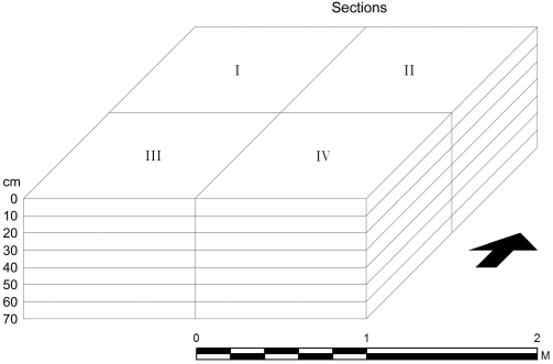
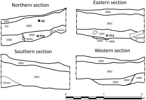
A systematic sampling method was used for the collection of samples from trench 2/2013, i.e. always four samples of a 10 cm thick layer were taken (Figure 3). A total of 32 samples with a total volume of 641 litres were gathered. The aim of the detailed sampling was to obtain a representative amount of plant macro-remains and on their basis reconstruct the species composition of the cultivated plants along with the structure of the plants potentially collected and brought to the settlement, and the environment at the site of the direct sedimentation of diaspors. The anthracological analysis was aimed at the reconstruction of the composition of the woods used and the activities connected with its use in the inner settlement area adjacent to the inner rampart (e.g. fire wood × timber). The analysis of flotation residues was conducted with the aim of obtaining minor artefacts and ecofacts, including non-floating charred material. Samples were collected and analysed for pollen from the individual stratigraphic layers (Figure 4).
2.2 Analytical methods
2.2.1 Analysis of plant macro-remains
The samples were floated using the flotation method and all the plant macro-remains and charcoals were removed. The entire sample volume was inspected with a stereomicroscope. Basic literature (Anderberg 1994; Berggren 1981; Cappers et al 2006; Hajnalová 1993; Hajnalová 1999; Lhotská, Chrtková 1978; Jacomet 2006) and the comparative collection of the Laboratory of Archaeobotany and Palaeoecology, Faculty of Science, University of South Bohemia were used in the identification process.
2.2.2 Anthracology
The individual charcoal fragments were fractured (transverse fracture) and viewed on a stereomicroscope at 40× magnification. Longitudinal and tangential fractures were additionally formed on the plasticine using a razor blade and viewed with an episcopic microscope at 250× magnification. The anatomical structures found were compared with the images in the Microscopic Atlas of Woods (Schweingruber 1978).
2.2.3 Palynology
The samples intended for pollen analysis were chemically processed. 1 g of the sediment from each sample was incubated in hydrofluoric acid, potassium hydroxide and acetylated to separate pollen grains from the remainder of the material (Faegri, Iversen 1989). A maximum of three prepared slides (24×60 mm) were inspected in a light microscope at 400–1,000× magnification and the pollen grains were identified and assigned into groups based on a key (Punt et al. 1976–2009; Beug, 2004). Mechanically damaged or corroded pollen grains were placed into the “varia” group.
2.2.4 Archaeozoology
Animal bone and teeth from the periods 1963–1966 and 2013 were identified at the Laboratory of Archaeobotany and Palaeoecology in České Budějovice. Changes in bone structure and colour caused by burning were described after Shipman et al. (1984).
2.2.5 Food detection by antibodies
During the processing of the ceramic assemblage from systematic excavations, three sherds with macroscopically visible potential accretions were set aside and subsequently analysed using the tests for the food antibody detection (Table 2). These tests have been used to a limited extent for the archaeological material (e.g. Pavelka, Vařeka 2008; John, Pavelka 2010).
2.2.6 Phosphate analysis
The collected samples were analysed with the colorimetric method for determining phosphorus oxide as molybdovanadate phosphoric acid according to Kitson and Mellon (1944). The methods for acid extraction of soil samples were modified to avoid tan discolouration of the extract due to carbonaceous soil components, with these components being burned prior to extraction. A LANGE photocolorimeter was used for the colorimetric measurement (Kordač 1964, 1965).
2.2.7 Volume Magnetic Susceptibility
Magnetic susceptibility was measured in situ by a KT3 Satisgeo Brno capameter on the profile cross-section in trench 1/2013 (Figure 5). This method was also applied to the experimentally burned samples of the same rock collected in the settlement area in order to determine the maximum firing temperature of the burned stones. Five fragments of biotite gneiss were successively burned in a muffle furnace at temperatures of 300°, 400°, 500°, 600° and 700°C; they were always baked at this temperature for at least 20 minutes. Their colour was consequently subjectively evaluated and susceptibility measured. The ignited stones were crushed and left to stabilize in the dishes for more than a month in the sun and rain. Their colour was subsequently determined and susceptibility measured.
2.2.8 Remanent magnetization
The selected stones (two stones from the interpreted front stone partition and two from the inner armature of the rampart) were in situ measured for the orientation with respect to the cardinal points and gradient to the horizontal plane (K1–4; Figure 2). The samples were omnidirectionally demagnetized in a coil in a laboratory with a weak alternating field of 50 Hz and the undesirable viscous magnetization was reduced. The stones were subsequently measured with a magnetograph consisting of a protractor, a magnetometer, RC filters with selectable time constants for phlegmatization of the civilization interference (Lowrie 2007), a DC amplifier with a gain of 1 to 1,024× and a XY plotter coordinate recorder. The magnetograph makes possible the recording of the subject -excited field in all the Gaussian positions and continuous registration of the field depending on the angle of the studied object. The internal magnetic declination towards contemporary north was determined for a stone placed in a dish in the spatial orientation in situ. The stones were consequently adjusted with a diamond saw to the appropriate isometric shape and the conserved magnetic inclination was measured.
2.2.9 Radiocarbon dating
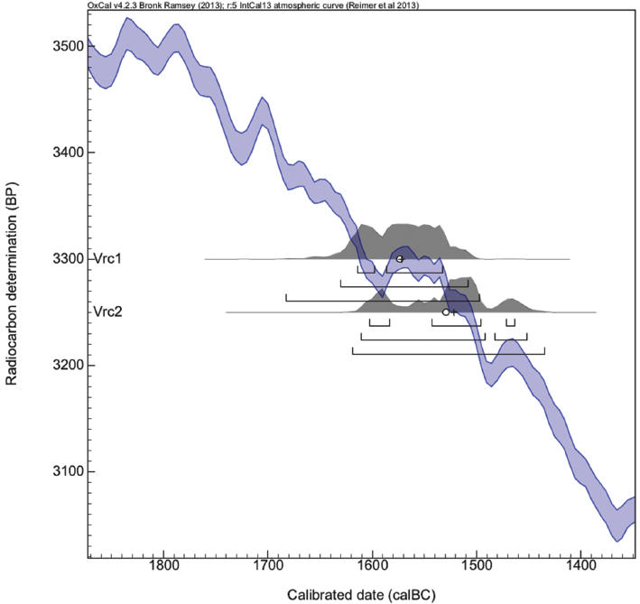
The AMS method was employed for radiocarbon dating of two samples (Table 4) of seeds from contexts 1006 and 2005 at the Center for Applied Isotope Studies at the University of Georgia (CAIS). Calibration of radiocarbon data, based on the calibration curve IntCal 13 (Reimer et al. 2013), was performed using the application OxCal 4.2 (Ramsey 2009).
2.3 Statistics, data visualization
Archaeobotanical data were processed using Tilia 1.5.12 software (Grimm 2011). The dependence of the occurrence of the species recorded by plant macro-remains and charcoal analyses in the individual samples from the trenches 1/2013 and 2/2013 was tested with a multivariate analysis according to ter Braak and Šmilauer (1998). Direct ordination (CCA) was used within trench 2/2013 for testing the relationship between the plant species composition, the conditions of its fossilization and volume of the floated material, the relationship to one of the four defined sectors, and the relationship to the stratigraphic or mechanical layer.
3. Results
3.1 Archaeobotany
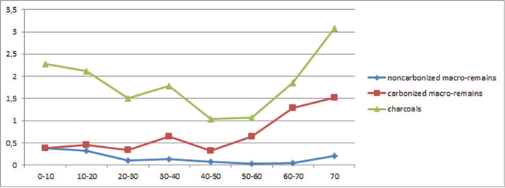
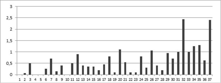
The concentration of plant macro-remains and charcoals per litre in the samples was extremely low. The average concentration in trench 1/2013 was 0.32 macro-remains per litre and 4.76 charcoals per litre, in trench 2/2013 0.64 plant macro-remains per litre and 1.64 charcoals per litre (Figure 7). Differences in the individual samples were large, however (Figure 8).
3.1.1 Analysis of plant macro-remains
The samples from trenches 1/2013 and 2/2013 differ significantly in their structures. The non-carbonized part of the plant macro-remains prevails in trench 1/2013 (95.93%). The age of this component could not be definitively accepted as prehistoric and was consequently not included into the analyses. A carbonized fraction of a hazel nut from Layer 1006 was radiocarbon dated. Trench 2/2013, in contrast, demonstrated a predominant component of carbonized plant macro-remains (81.87%). Fractions of carbonized grains from Layer 2005 were radiocarbon dated. In terms of methodology, a key finding was that a substantial part of the carbonised plant macro-remains (12.35%) in trench 2/2013 were preserved in a fraction of the flotation residues: taxa, primarily fragments of hazel nuts and sloe stones, were consequently identified. Carbonised plant macro-remains were not detected in the flotation residues from trench 1/2013.
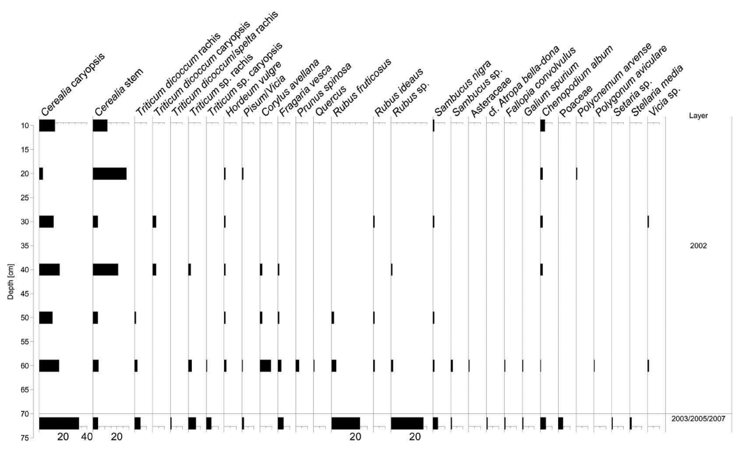
Carbonised plant macro-remains originated only from Layers 1004 and 1006 in trench 1/2013 (Table 3). An additional undefinable vetch seed was found (Vicia sp.) in Layer 1004 and broken cereal stalks (Cerealia), a fraction of a hazelnut shell (Corylus avellana), raspberry achene (Rubus sp.) and elderberry seed (Sambucus nigra) in Layer 1006. Layers 1003, 1008, and 1010 did not contain charred plant macro-remains. In the sample set from trench 2/2013 (for more details per layers see Figure 9), cereal remains prevailed (59.44%), residues of plants which were presumably collected and used for food were also significantly represented (31%) and plants from fields and rubbles were represented to an amount of 8.6%.
The remains of cereals were transferred to the minimum number of individuals (MNI) by counting three fractions of grains as one whole kernel and complete spikelets as two halves (one whole spikelet in the ear contains two grains). The set of cereal remains was considerably damaged. Cereal stalk fractions were predominant in the set (37.56%). Unidentified grains constituted 34.27%. Emmer wheat (Triticum dicoccum) was found in the form of grains (2.82%) and spikelets (6.57%) in the identified cereals. Some of the wheats could not be specified in more detail (T. dicoccum/spelta, Triticum sp.). The ratio of hulled wheat grains to spikelets is 1:3.9. The supplementary cereal in the set from Vrcovice was barley (Hordeum vulgare; 5.16%).
Legumes were represented by one further unspecified seed of vetch or peas (Vicia/Pisum).
A significant amount of the set (31%) was formed by the remains of potentially collected plants used for food. The number of identified specimens (NISP) was transferred to the MNI by transferring three quarters of the given taxon to one potential find. These plant residues, usable as fruit, include blackberry (Rubus fruticosus), unspecified raspberry (Rubus sp.), and raspberry (Rubus ideaus; 40.21%, 18.56%, and 4.12%, respectively). The achenes of strawberry (Fragaria vesca) make up 13.40% of the potential utility plants. Elderberry seeds form 8.25% and unidentified elderberry 4.12%. In addition, fractions of hazel nuts (Corylus avellana 7.22%), fractions of blackthorn stones (cf. Prunus spinosa 2.06%), acorns (Quercus sp. 1.03%) and seeds in all probability of belladonna (cf. Atropa bella-dona 1.03%) can also be considered remains of potentially collected plants.
Segetal and rubble vegetation represent only 8.16% of the set. Achenes of white goosefoot occur more frequently. An extremely small quantity of the following taxons was documented: Asteraceae, Fallopia convolvulus, Galium spurium, Poaceae, Polycnemum arvense, Polygonum aviculare, Setaria sp., Vicia sp. Parts of these plants can also be used.
3.1.2 Anthracological analysis
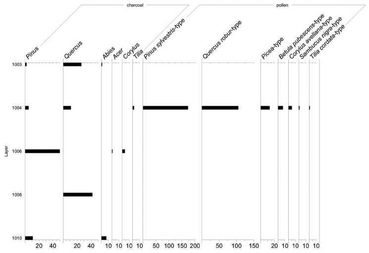
Charcoals of wood were found in five layers of trench 1/2013 (Figure 10). Charcoals of oak (Quercus sp., 89.65%) were predominant in the upper part of the wall in Layer 1003. Charcoals of Scots Pine (Pinus sylvestris, 6.9%) and chars of Silver Fir (Abies alba, 3.45%) were also recorded. Oak charcoals (61.11 %) were also predominant in Layer 1004 which forms the middle part of the profile, Scots Pine (27.78%) and lime trees (Tilia sp., 11.1%) were abundantly represented. Charcoals of Scots Pine (90.91%) were predominant in Layer 1006; other woods in this layer include charcoals of hazel (Corylus avellana, 7.27%) and occasionally maple (Acer sp., 1.82%). Layer 1008 was only represented by oak; Layer 1010 contained only Scots Pine (61.11%) and Silver Fir (38.89%).
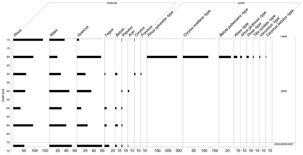
Charcoals from trench 2/2013 were assessed in the units after mechanical layers (Figure 11). The stratigraphicly lowest part of Layer 2002 from a depth of 70 cm was assessed as part of the sixth mechanical layer. Features 2003, 2005 and 2007 were pooled and assessed simultaneously. Charcoals of Scots Pine (Pinus sylvestris) were predominant in the entire set from trench 2/2013. The codominants of the set were charcoals of Silver Fir (Abies alba) and oak (Quercus sp.). Additional woods determined in trench 2/2013 include maple (Acer sp.), birch (Betula sp.), hazel (Corylus avellana), common beech (Fagus sylvatica), common ash (Fraxinus excelsior) and poplar (Populus sp.). Despite similarities in the anthracological set within the studied mechanical layers, a marked increase in the representation of Scots Pine and a decrease in species diversity are apparent in the upper parts of the profile.
3.1.3 Pollen analysis
Eight samples were taken from the profile of trench 1/2013, pollen was only preserved in sample P4 (Figure 2), with the total number of pollen grains per three slides being 408. Out of the three samples taken from the profile of trench 2/2013, only one sample was positive, with the total number of pollen grains per three slides being 526 (P9; Figure 4). Both positive samples were similar in terms of the structure of the preserved pollen groups (Table 5), with the spectrum of woods prevailing over herbs in both of them.
Pollen of woods from Layer 1004 (Figure 10) made up 75.49% of the sample; the predominant occurrence was identified for pine (Pinus sylvestris-type) and oak (Quercus robur-type), a low occurrence was detected for spruce (Picea-type), hazel (Corylus avellana-type), lime (Tilia cordata-type), birch (Betula pubescens-type), and elder (Sambucus nigra-type).
Herbs made up 12.25% of the set, with a predominating species of the Poaceae family. An occurrence of the pollen of anthropogenic indicators, namely cereals (Cerealia), e.g. rye (Secale cereale), was recorded. No less interesting are finds of pollen of cereal weed and cornflower (Centaurea cyanus-type). In addition, pollen grains of plantain (Plantago lanceolata), common knotgrass (Polygonum aviculare-type), representatives of the Goosefoot family (Chenopodiaceae) and the Cabbage family (Brassicaceae), pollen types of St John’s wort (Hypericum perforatum-type), tall buttercup (Ranunculus acris-type), milkvetch (Astragalus-type) and chickweed (Cerastium fontanum-type) were detected. Shares of ferns formed 7.53% of the set. Material which could not be identified contained 4.17% pollen grains.
Pollen of woody plants (Figure 11) made up 82.90% of sample P9 from Layer 2002 (trench 2/2013); with a predominant occurrence of pine (Pinus sylvestris-type) and hazel (Corylus avellana-type), with an admixture of pollen of birch (Betula pubescens-type). Low amounts of pollen of fir (Abies-type), alder (Alnus glutinosa-type), hornbeam (Carpinus betulus-type), spruce (Picea-type), lime (Tilia cordata-type), and lingonberry (Vaccinium-type) were found.
Herbs made up 11.03% of the set. The representation of pollen types was similar to that in sample P4. Anthropogenic indicators as cereals including rye (Secale cereale) and a grazing indicator as narrowleaf plantain (Plantago lanceolata) were present. The occurrence of corn spurrey (Spergula arvensis-type) is also of interest. The spores of ferns accounted for 2.57% and the unidentified pollen grains for 3.49%.
3.2 Archaeozoological analysis
The osteological material obtained from the systematic research over the period of 1963–1966 contained remains of burned bones and the teeth of mammals (Table 6). The short species list results from the small size of the findings, an absence of morphological features and bone damage caused by burning. Due to the above-mentioned reasons, in certain cases, it was not possible to unequivocally decide between the human and animal remains. 579 animal remains with a total weight of 946 g were registered in total. The average weight of one fragment was low – 1.6 g. The considerable fragmentarization of the bones influenced the lower level of taxonomic attribution (only 14 finds, i.e. 2.4% of the total specimens were identified). The colour of all the burned bones and teeth varied between grey and white (exceptionally black). Although the colour of the bones is not a reliable indicator for accurate temperature estimation, the bones found in Vrcovice could have been intensively burned away at 600° C. This phenomena is manifested both by the destruction of the bone organic fraction and by the recrystallization of bone mineral (Shipman et al. 1984). The few specimens (e.g. teeth and postcranial bones) were identifiable to cattle (Bos taurus) and pig (Sus sp.). The majority of the material (97.6%) was classified as indeterminated mammals. The category “indeterminate mammals” nevertheless also contained medium or large-sized mammals; e.g. the fragments of long bones or scapula of these categories were found. Unfortunately, the obtained dataset did not permit a formulation of relevant conclusions.
953 fragments of mammalian bones and teeth were found in trenches 1/2013 and 2/2013 (Table 6). The weight of all the bone remains was 16.9 g. Trench 2/2013 contained absolute majority of finds (N=948, i.e. 99.5% of the total specimens found in both trenches) compared with trench 1/2013 (N=5, i.e. 0.5%). All the skeletal fragments were extremely small and had a white colour since they were burned at temperatures exceeding 600° C (Shipman et al. 1984). The damaged cervical vertebra of an adult small-sized rodent (Rodentia) was found in trench 1/2013 (Layer 1006). The remainder of the osteological material from this context was not classified into the taxonomic categories. The bone fragments from trench 2/2013 were not taxonomically determined due to their high fragmentarization and charring. Apart from the residues of the crowns of bunodont teeth (N=6) which could belong to several species (e.g. pigs, human) found in Layer 2002 (60–70 cm), the other parts of the damaged teeth (N=7), without more detailed identification, were discovered in Layer 2002 (30–40 cm and 60–70 cm).
Feature 2005 contained e.g. two small fragments of vertebrae of immature individual/individuals, one part of the rib of a small-sized mammal and two skull fragments of a medium-sized mammal.
3.3 Detection of food using antibodies
The presence of tested proteins was not detected in the two samples, one sample was positive. Casein indicating the presence of milk was detected; goat IgG was positive and bovine beta lactoglobulin negative, implying that the detected proteins were probably of goat origin. Thermostable proteins of domestic animals were negative suggesting that the sample did not contain meat in a detectable amount. Similarly, a negative test for gluten suggests that the sample did not contain cereals in a detectable amount. Ovomucoid proved to be positive, implying thus the presence of bird’s eggs.
3.4 Geoarchaeological methods
3.4.1 Phosphate analysis
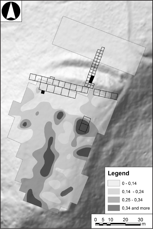
230 soil samples were analysed. Based on the phosphate content determined by the colourimetric method, the results of the measurement were split into four categories: 0–0.14% – normal; 0.15–0.24% – mildly increased; 0.25–0.34% – medium increased; 0.35 and more – strongly increased (Kordač 1965). In the inner area of the settlement, several phosphate concentrations were found while the measured area of the foreland proved to be sterile (Figure 12).
3.4.2 Magnetic susceptibility
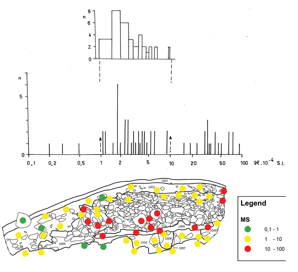
The stone component of the rampart was primarily formed by biotitic and muscovite gneisses stained by heat to brown – pink – reddish. These stones change their character at relatively low temperatures. Experimental firing showed that up to 300° C, the stone does not tend to acquire shades of red, however, with higher temperatures all the stones obtain nearly the same visually indistinguishable, colour. Experimental oxidative annealing failed to achieve such a huge increase in the magnetic susceptibilities as detected in most stones of the wall measured in situ. This was in all probability caused by reduction firing. Out of the 24 randomly collected stones at the site, medium magnetic susceptibility 1.27 plus/minus 0.77 with extremes of 0.1 to 3.3×10⁻⁴ SI units was determined. The statistical classification (histogram) of stones in the rampart indicates three groups of susceptibility values: scarcely represented (0.1 to 1), stones apparently were not subject to heat; normally burned (1–10); anomalous maximum of 10 to 100, extremely high values. Spot measurements of magnetic susceptibility in situ revealed elevated levels of the “Black Layer” 1006, front stone partition 1005 and parts of the interior stone armature 1004 (Figure 5).
3.4.3 Remanent magnetization
Based on measurement of conserved magnetism, stones K1 to K4 (Figure 2) can be considered as relatively unmoved since the fire cooled (Table 7).
Primordial fluctuation of declinations of approximately ±25° in declination and currently at approximately 67±10° in inclination can be interpreted as normal. Stones K3 and K4 can be assessed as factually unmoved. Stones K1 and K2 in all probability swelled, but did not turn. This is illustrated by the conserved inclination and the strikingly askew positions of the stones.
3.5 Radiocarbon dating
Two radiocarbon data were obtained using the AMS method. One of these was from Layer 1006, located at the base of the inner rampart, and the other from feature 2005 from trench 2/2013 (Table 4; Figure 6). The resulting data fall broadly into the 16th century BC. This finding corresponds to the typological analysis of numerous ceramic finds from the hillfort (Hlásek et al. in press). The same agreement between this type of pottery and radiocarbon dating comes from Bohemia from a nearby burial mound in Dobešice (Krištuf, Rytíř 2009) and the oldest phase of the hillfort Pilsen – Pod Homolkou (unpublished excavation by L. Šmejda).
4. Discussion
4.1 Formation processes
Vertically, the character of the trench 2/2013 is not fully consistent (Figure 7). Concentration of the non-carbonised macro-remains decreases in the direction from the trench surface to the bedrock, concentration of the charred macro-remains increases, concentration of charcoals declines to 40–50 cm, then rises once again. Higher concentrations of carbonised macro-remains and charcoals apparently characterize the fills of the features above the bedrock. The layers to a depth of 40–50 cm from the surface could have consequently been more affected by erosion. This was presumably caused by a shift in the original cultural layer and the associated destruction of the organic material. When considering the preservation of relatively fragile macro-remains (e.g. strawberry achenes, raspberry stones, etc.) along with the high degradation of grains (often identified as only cereal), it can be assumed that the layer was created under the influence of several processes (e.g. cereal processing, fruit processing,waste depositing) and reflects a number of kinds of human activities (redeposition of the cultural layers in the sloping terrain has been studied for example in Kostelec nad Vltavou – see John et al. 2012, where macroremain destruction due to layer redeposition has been demonstrated).
The results of the analysis of the plant macro-remains and charcoals, based on the correspondence analysis of the dependence of the occurrence of species in the individual samples, reveals the similarities of the samples taken from trenches 1/2013 and 2/2013. This similarity may be caused by the fact that the sets from both trenches come from an extremely narrow chronological horizon and were formed in the same environment on the promontory above the Otava River. Direct ordination analysis (CCA) points out that samples one (1003) and two (1004), from trench one compared to other samples are characteristic of a different content of species, particularly species in a non-carbonized state. These layers reflect the different composition of vegetation with younger plant material penetrating into these layers as indicated by the presence of uncharred macro-remains and species such as Secale cereale or Centaurea cyanus in the pollen spectrum. Their occurrence is traditionally primarily associated with medieval horizons (Kozáková et al. 2009). Pollen grains of rye and cornflowers occasionally occur, however, in pollen diagrams coming from the upper parts of the Bohemian Forest from the sub-boreal zones, (Svobodová et al. 2001; 2002). Contamination with materials from later periods cannot be completely ruled out in the samples from Vrcovice.
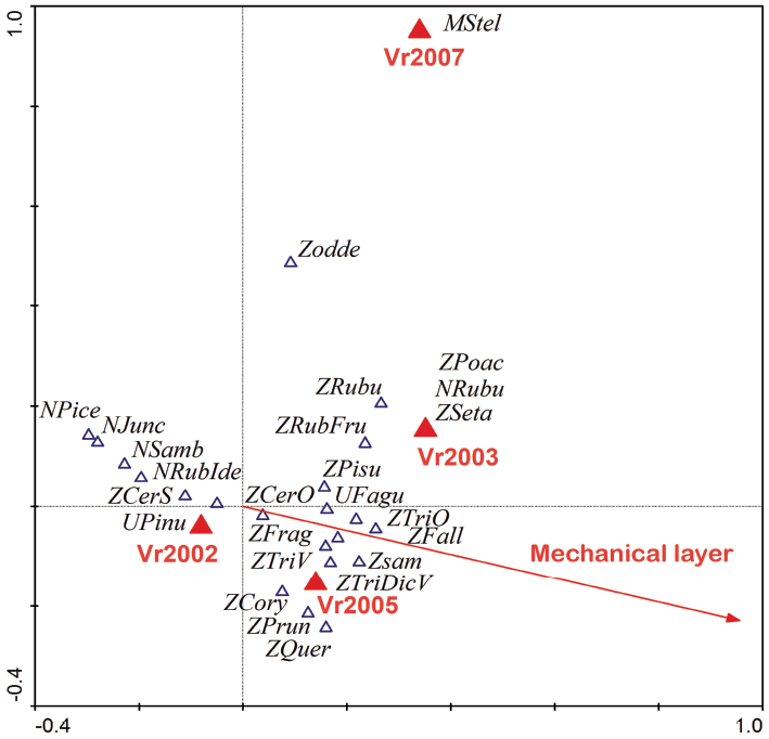
The technique of direct ordination (CCA) was used within trench 2/2013 for testing the relationship between the species composition and the volume of the floated material, the relationship to one of the four defined sectors and the relationship to the stratigraphic or mechanical layer (Figure 13). The results indicated that the volume of the collected material (in certain cases a standard amount could not be taken due to the small thickness of the layer) and the relationship to the sector do not explain the distribution of the species data at a significance level p<0.01. In contrast, the correspondence to the mechanical layer significantly explained (p<0.05) the total variability of 9%, and, also significantly, the correspondence to each stratigraphic layer (p<0.05), the total variability of 15.4%. Both factors were significantly correlated. The explained variability common to both factors achieved 2.2%. The total variability at the ordination of both factors was 22.2%.
The results suggest that non-carbonised (N) macro-remains occur in the layers closer to the surface. The occurrence of charcoals (U) was also typical for these layers. Carbonized (Z) macro-remains consequently occurred in lower layers. They in all probability also characterise Layer 2005 defined as a filling of the feature (cereals, ruderals, elderberry). The layers defined as fills of the features (Layers 2003 and 2007) were primarily characteristic of the highly degraded macro-remains of blackberry and carbonised remains of bristle grass and grass (for more details see Figure 9).
Non-carbonised macro-remains near the surface could be considered as contamination. The differences between layers 2002, 2005 and 2003, 2007 could reflect additional passed processes of the layers prior to deposition and a different stage of plant remains degradation.
4.2 Fortification layout
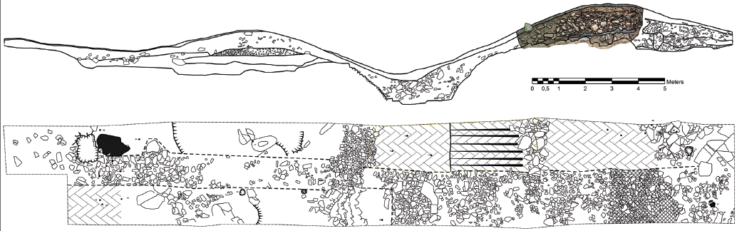
The fortification of the settlement in Vrcovice currently ranks among the most important resources for study of fortifications at the turn of the Early and Middle Bronze Age in Bohemia (compare Čtverák et al. 2003, 16). This is due to the preservation of the above-ground relics, the single-phase settlement and the extensive archaeological research conducted at the site. The relics of fortification (25 metres wide) form the front wall; the ditch and the inner wall are in terrain relief evident in the length of approximately 80 m. The curved walls on the south-west side indicate the original course of the wall to the west side of the fortification (Figure 1). The curved base of the interior rampart was also unearthed at the eastern side of the inner wall. It can therefore be assumed that the original fortification enclosed the settlement area to a far greater extent than shown by the relicts. Construction of the entire fortification was primarily documented by research conducted in 1964 (Figure 14). The outer rampart was formed by several supporting parallel palisades with irregularly placed poles. The inner space between the palisades, approximately 2.5 m, was filled with loose earthy material. The ditch with sloping sides and a flat bottom was carved into the rocky ground. The width of the ditch was 6.5 m at the level of the surrounding bedrock in the cross section; the bottom width was approximately 2.5 m and the depth of the presumed original terrain ca 2 m.
The construction of the inner rampart was the most complicated. Prior to its construction, the bedrock had been levelled. The bedrock is topped by a sandy layer 1010 with an admixture of weathered bedrock at certain points, which provided only charcoals of fir and pine. The layer can be interpreted as a reflection of activities performed at the site of the fortification prior to its construction. Concerning the presence of fir charcoals, the destruction of previous constructions cannot be eliminated. It is extremely likely, however, that the firs and pines were a natural component of the woods surrounding the Vrcovice promontory, reflecting thus the surface of the terrain. The stake holes were embedded into Layer 1007 with burnt soil of a pink colour. Filling 1008 consists entirely of oak charcoal and can thus be considered the remainder of the hole. It is not evident whether the hole was part of the inner construction of the fortification or whether it was connected with the original lighter fortification or another activity. The existence of possible previous activities is also supported by the relatively low value of magnetic susceptibility compared to the covering layer. The rampart itself was limited by the stone shell from both sides. An approximately metre wide berm was situated in front of the outer shell. The bottom part of the outer shell was formed by a stone row, its upper preserved part was recorded in the profile during the revision research (1005; Figure 2). The basis of the inner shell was also formed by a row of large stones with holes for the supporting stakes found behind them. Out of the interior rampart foundations, black Layer 1006 on the overlying rock base was preserved and radiocarbon dated. The layer primarily contained charcoals of pine, charcoals of hazel and maple in a smaller amount, remains of hazel nuts, grains and the seeds of elderberry and blackberry; a fragment of the cervical vertebrae of a small rodent was detected. The layer inhomogeneity was observed macroscopically. This was formed by the prevailing black component containing a large amount of phosphates. The humic acid test was also positive. A light layer similar in its character to Layer 1010 was less represented. It was unearthed during the research in 1964 (in all probability of a width of 2 metres; Figure 14) and was described as a layer of burned wood. Layer 1006 can thus be interpreted as the remains of burned pine grade and simultaneously as the remains of the cultural layer.
The rampart armature itself (1004) was formed of stones with a minimum portion of soil. The original internal timber construction was demonstrated by the measurement of magnetic susceptibility. Its increased values arose from sites of reducing burning of wooden elements which, as indicated by the measurement, were found at the external shell, in the middle of the wall and partially on the south side of the trench profile. Layers 1003 and 1004 are characteristic of numerous pieces of oak charcoal. Oak charcoals can be viewed as the destroyed remains of the timber rampart construction. Layer 1003 also marginally contained the burned wood of fir and pine. In Layer 1004 (stone armature of the rampart) oak charcoal is supplemented with charcoal of lime and pine. The lime and pine were presumably natural components of the surrounding vegetation which may have become a component of the rampart destruction as a result of post-deposition processes.
Abundant daub with impressions found on the destroyed rampart on the inner slope of the wall implies that the upper part of the rampart was formed by a wicker frame neatly covered with clay. Due to the longer life of the filling, the wicker frame must have been roofed (Netolický, in press).
The rampart was destroyed by fire, with a varying maximum burning temperature. A number of stones from the destruction are almost completely melted, with the red colour of the local biotite and muscovite gneisses penetrating the entire stone armature 1004, developing already at 300° C, as has been experimentally demonstrated. The determined high magnetic susceptibility was primarily caused by reducing burning; the burnt-out area was presumably fuming for a longer time. The rampart primarily collapsed towards the settlement area, in all probability by a loosening of the internal load-bearing poles. The direction of the slide of the inner rampart is evidenced by the boundary of the rampart destruction captured in the trench in the hillside of the inner wall (Figure 1) and the noticeable askew position of the stones of the exterior partition. This prompted the measurement of conserved magnetism in order to determine the position of the selected stones during the fire. While the position of the two stones inside the armature was practically unchanged, the other two selected stones from the shell moved towards the ditch but did not reverse.
4.3 The economic system
The osteological remains of domestic animals, specifically cattle and pigs, were determined in the material obtained from the Vrcovice settlement. Both adult and young animals were confirmed, presumably indicating the breeding of animals at the settlement. The analysis of the residuum from the pottery demonstrated the use of goat milk and bird eggs. Important cereals included emmer, wheat and barley, with evidence for their processing being found directly in the area of the hillfort (the base of husks). Peas or vetch were used in terms of legumes. A collection of wildly growing fruits (hazel nuts, sloes, blackberries, raspberries, strawberries and elderberry) could have also played an important role for the inhabitants of the settlement (for a discussion on the topic of collected wild plants see e.g. Bouby, Billaud 2005). A high portion of potentially collected fruits is not particularly common in the prehistoric objects in Central Europe in a dry condition (for a culturally connected situation e.g. Fröhlich et al. 2004; Schmidl, Oeggl 2005; Wiethold, Wähnert 2008). A similar structure of grown plants was also found in other South Bohemian localities of that period (Planá near České Budějovice, Dub-Javornice in the Prachatice region; preliminary see Šálková 2011).
The material obtained in the area of trench 2/2013 could correspond to the deposit of (burned) waste as suggested from the teeth fractions in Layer 2002 (unidentified species, or bunodont teeth – e.g. pig, human). Layer 2005 (fill of the feature) yielded fragments of vertebra of a physically immature individual, a fraction of the rib of a small-sized mammal and fragments of the skull of an unspecified middle-sized mammal. The character of the waste can be also seen in the structure of the recovered remains of the crops – in the hulled wheat, the number of husk bases exceeds the number of grains, most grains is so damaged (in all probability by too high of a charring temperature) that their further specification is impossible. The assemblage contains plant macro-remains which were originally part of the rubble or segetal vegetation (this may be interpreted as cleaning of grains or seed sedimentation in the place of charring, perhaps burning of waste).
Places with higher phosphate content (Figure 12) may constitute refuse subareas, processing sites or manipulations of organic materials or livestock housing space. The trench opened at the site of one of the phosphate concentration during systematic research in 1965 did not unfortunately produce results which would allow for a more specific interpretation.
4.4 The natural environment
A map of potentially natural vegetation in the area of the Vrcovice promontory reconstructs Luzulo albidae-Quercetum petraeae, abietates-Quercetum, then only Melampyro nemorosi-Carpinetum in the hinterland (Neuhäselová 2001).
Oak-hornbeam forests are characterised by the predominance of Quercus petrea and Carpinus betulus, mixed with Tilia cordata or T. platyphyllos, Quercus robur and a habitat of demanding deciduous trees – Fraxinus exelsior, Acer platanoides, Acer pseudoplatanus. Abies alba and Fagus sylvatica also occur in this type of vegetation in the colinous phase.
Acidic beech forests (as. Luzulo-Quercetum) are light oak woods with predominating Quercus petraea or Q. robur, with the addition of Betula pendula, Pinus sylvestris or in the past, Abies alba in the tree and shrub layer.
A combination of multiple archaeobotanical analyses makes it possible to reconstruct the deposition of plant remains in the cultural layers and features infills reflecting human activities (Deforce 2010; Smith 2013), in order to provide details on the functioning of the site (Bosi et al. 2011) as well as to specify local habitats and environmental conditions at the archaeological sites (Pokorná et al. 2014; Święta, Musznicka et al. 2013). The spectrum of charcoal remains recorded in the archaeological features is usually influenced by human selection (Théry-Parisot et al. 2010) and the use of results from two positive pollen samples is somewhat insufficient for the environmental reconstruction of the wide surroundings of the hillfort. We can expect, however, that at least some arboreal pollen deposits would have been affected by the pollen rain of trees located at the hillfort or its surroundings. Wood used as fuel and for building activities also usually comes from nearby areas.
The reconstruction of the hillfort surroundings from palynological data obtained from adjacent natural archives is quite problematic. Data from the adjacent are still lacking. The majority of the nearby cores originate from different natural habitats – from the Bohemian Forest mountain mires (Svobodová et al., 2001; 2002) and the Třeboňsko basin marshlands (Jankovská 1980; Pokorný, Jankovská 2000). Even the relatively close core located at Kožlí (Pokorný, Kuneš 2009) is not sufficient for reconstruction of the hillfort surroundings, since it comes from small spring mire. The pollen record of alluvial sediment by Sepekov also corresponds to fairly local vegetation development (Houfková et al. 2011). Referenced data has enabled us, however, to compare our results with general palynological trends, primarily on the basis of the pollen record originating from the relatively large water surface of the ca 10 km distant Řežabinec (Rybníčková, Rybníček 1985). As documented in this pollen record and in pollen assemblages from the Bohemian Forest, the fir pollen curve reaches its maximum in the sub-boreal zone (Svobodová et al. 2001; 2002). Fir pollen grains are not transported all that far, the majority of the pollen grains settle within 0.5 km of the parent tree (Eisenhut 1961). Despite this fact, the regional pollen fallout should still provide values of ca one percent of the entire pollen grains of trees and shrubs (Pidek et al. 2013). The complete absence of fir pollen grains in sample P4 could reflect several factors: a lack of productive trees around the hillfort, the construction/destruction of the rampart during less productive years, the rapid erection/destruction of the rampart in the non-flowering period of fir trees. The latter is in contradiction with the presence of the pollen grains of oak and pine, due to their overlapping flowering period (Hájková et al., 2012).
The anthracological assemblage obtained from a cross-section through the wall, i.e. the profile of trench 1/2013, is outstanding not only due to the low species diversity (6 species of trees) but also due to the high percentage of representation of oak and pine forest (Figure 10). All the wood species captured by the anthracological analysis in the destruction of the rampart were originally in all probability part of the natural vegetation (woodrush and / or fir oak woodland) around the promontory.
The structure of the charcoals in trench 2/2013 reflects higher species diversity (9 wood plant species) with predominating charcoals of pine forest and frequently occurring charcoals of oak and fir. Trench 2/2013 caught charcoals of maple, birch, hazel, beech, ash tree and poplar in small quantities (Figure 11). This structure of wood corresponds to the woodland with the occurrence of beech, but also heliophilous trees. It may reflect the firewood obtained around the promontory and used in the settlement area. The oak and fir may suggest, however, the presence of destroyed structures.
A comparison of the structure of the charcoals derived from the body of the wall with the layers from trench 1/2013, which preceded the construction of rampart (1010) and the layer in the wall formed after the destruction of rampart (1003) with the contexts from trench 2/2013, reveals an interesting absence of charcoal in the rampart body, while fir is documented in other contexts. This situation is also reflected by the absence of fir pollen in sample P4. The cultural layer trapped under the inner rampart indicates that the site had been used prior to the construction.
Although charcoal of fir were deposited in the area below the rampart at the time of a formation of the layer 1010, the use of fir was not recorded for the subsequent construction of the inner rampart, and given the fact that it is not detected in the pollen spectrum, the absence of fir can be assumed within the vicinity of the settlement at the time of the rampart construction. Fir is again documented in layer 1003 (formed after the extinction of the rampart).
5. Conclusions
This study presents the results of environmental methods used mainly in research conducted in 2013 at the hillfort from the beginning of the Middle Bronze Age in Vrcovice. It has been documented that the fortified settlement at the beginning of the Middle Bronze Age was intensively settled and did not merely serve as a refuge (compare the opposite view of Dubský 1949, 131). The presence of a cultural layer and radiocarbon data suggest that the promontory was actually used prior to the construction of the inner rampart, which has been subject of the research. Previous enclosures were not reliably documented in this area, however, although the presence of previous constructions may be assumed from stake hole 1007. The rampart was destroyed by fire and collapsed towards the inner settlement area.
Acknowledgements
This study was partially supported by projects: (SGS-2013-060) Hillfort at Vrcovice, Písek region. Questions of subsistence and the appearance of elevated hillforts from the turn of the Early and Middle Bronze Age; (GA JU 116/2013/P) Bioarchaeology of South Bohemia; and (CZ.1.07/2.3.00/20.0289) PAPAVER – Centre for human and plant studies in Europe and Northern Africa in the postglacial period.
References
ALUŠÍK, T. 2012: Aegean Elements and lnfluences in Central European Bronze Age Defensive Architecture: Fact or Fiction? Local or lmported? In: Jaeger, M., Fischl, K. P., Czebreszuk, J. (Eds.): Enclosed space – open society. Contact and exchange in the context of Bronze Age defensive settlements in Central Europe. Studia nad Pradziejami Europy Środkowej/Studien zur Archaeologie in Ostmitteleuropa 9, Poznań, Bonn, 11–25.
ANDERBERG, A. L. 1994: Atlas of seeds and small fruits of Northwest-European plant species with morphological descriptions. Part 4 Resedaceae – Umbeliferae. Stockholm.
BENEŠ, A. 1966: Habitat fortifié près de Vrcovice en Bohême du Sud. In Filip, J. (Ed.): Investigations archéologiques en Tchécoslovaquie. Praha, 133.
BERGGREN, G. 1981: Atlas of seeds and small fruits of Northwest-European plant speces with morphological descriptions. Part 3 Salicaceae – Cruciferae. Stockholm.
BEUG, H. J. 2004: Leitfaden der Pollenbestimmung für Mitteleuropa und angrenzende Gebiete. Verlag Friedrich Pfeil, München.
BOSI, G. M., BANDINI MAZZANTI, A., FLORENZANO, I., MASSAMBA N’SIALA, A., PEDERZOLI, R., RINALDI, P., TORRI, A. M., MERCURI, A. M. 2011: Seeds/fruits, pollen and parasite remains as evidence of site function: Piazza Garibaldi–Parma (N Italy) in Roman and Mediaeval times. Journal of Archaeological Science 38, 1621–1633.
BOUBY, L., BILLAUD, Y. 2005: Identtifying Prehistoric Colected Wild Plants: A Case Study from Late Bronze Age Settlements in the French Alps (Grěsine, Bourget Lake, Savoie). Journal of Economic Botany 59(3), 255–267.
BOUZEK, J. 2009: Pravěk českých zemí v evropském kontextu. 2nd edition, Praha.
ter BRAAK, C. J. F., ŠMILAUER, P. 1998: CANOCO Reference Manual and User’s Guide to CANOCO for Windows:Software for Canonical Community Ordination (version 4). Microcomputer Power, Ithaca, New York, USA.
CAPPERS, R. T. J., BEKKER R. M., JANS J. E. A. 2006: Digitale Zadenatlas van Nederland / Digital Seed Atlas of The Netherlands. Groningen.
ČTVERÁK, V., LUTOVSKÝ, M., SLABINA, M., SMEJTEK, L. 2003: Encyklopedie hradišť v Čechách. Libri, Praha.
DEFORCE, K. 2010: Pollen analysis of 15th century cesspits from the palace of the dukes of Burgundy in Bruges (Belgium): evidence for the use of honey from the western Mediterranean. Journal of Archaeological Science 37(2), 337–342.
DEYL, M., UŠÁK, O. 1956: Plevele polí a zahrad. Praha.
DUBSKÝ, B. 1949: Pravěk jižních Čech. Blatná.
EISENHUT, G. 1961: Untersuchungen über die Morphologie und Ökologie der Pollenkörner heimischer und fremdländischer Waldbäume. Translated into English by Jackson, S. T. and Jaumann, P., 1989, Paul Parey, Hamburg.
FAEGRI, K., IVERSEN, J. 1989: Textbook of Pollen Analysis. Chichester.
FIŠERA, M. undated manuscript: Geologická situace nejbližšího okolí hradiště Bohuslav. MS. Expert report. Deposited: Archives of the Department of rescue archaeological excavations, Museum of West Bohemia, Plzeň.
FRÖHLICH, J., CHVOJKA, O., JIŘÍK, J. 2004: Mladomohylové sídliště v průmyslovézóně Písek-Sever. Archeologické výzkumy v jižních Čechách 17, 83–101.
GRIMM, E. C. 2011: Tilia. Version 1.5.12. Illinois State Museum, Springfield, Illinois, USA.
HAJNALOVÁ, E. 1993: Obilie v archeobotanických nálezech na Slovensku. Nitra.
HAJNALOVÁ, E. 1999: Archeobotanika pestovaných rastlín. Nitra.
HÁSEK, I. 1975: Hrazené osady věteřovského horizontu v Čechách. Časopis Národního muzea, řada historická 144, 105–118.
HLÁSEK, D., FRÖHLICH, J., CHVOJKA, O., MICHÁLEK, J., ŠÁLKOVÁ, T., HOUFKOVÁ, P., MAJER, A., MENŠÍK, P, NETOLICKÝ, P., NOVÁK, J., PAVELKA, J. in press: Vrcovice. Hradiště z počátku střední doby bronzové. Archeologické výzkumy v jižních Čechách – Supplementum 10. České Budějovice, Plzeň.
HOUFKOVÁ, P., BERNARDOVÁ, A., NOVÁKOVÁ, K., NOVÁK J. 2011: Sepekov – vodárna Závist: záznam mladoholocenní vegetační dynamiky jedlové olšiny. Rekonstrukce vegetačních změn v nivě říčky Smutná u Sepekova. In: Chvojka O. et al.: Osídlení doby bronzové v povodí říčky Smutné v jižních Čechách. Archeologické výzkumy v jižních Čechách – Supplementum 8. České Budějovice, 328–333.
JACOMET, S., KREUZ, A. 1999: Archäobotanik. Aufgaben, Methoden und Ergebnisse vegetations- und agrargeschichtlicher Forschung. Stuttgart.
JACOMET, S. 2006: Identification of cereal remains from archaeological sites. 2nd edition. Basel.
JAEGER, M. 2011: Central European Societies of Fortified Settlements in the First Half of the 2nd Millenium BC. Comparative Study of Trial Areas. MS. Doctoral thesis. Deposited: Adam Mickiewicz University. Poznań.
JANKOVSKÁ, V. 1980: Paläogeobotanische Rekonstruktion der Vegetationsentwicklung im Becken Třeboňská pánev während des Spätglazials und Holozäns. Academia. Praha.
JELÍNEK, P., HLAVATÁ, J., VAVÁK, J., BEŇUS, R., JAMRICHOVÁ, E. 2013: Natural Scientific Analyses at the Archaeological Excavations in Budmerice: Methods, Results, and Perspectives. Interdisciplinaria Archaeologica – Natural Sciences in Archaeology IV/1/2013, 39–61.
JOHN, J., PAVELKA, J. 2010: Imunologická analýza rezidua na vnitřní straně eneolitické nádobky z lokality Otmíče-Otmíčská hora (okr. Beroun). In: Krištuf, P., Vařeka, P. (Eds.): Opomíjená archeologie 2007–2008. Plzeň, 156–159.
JOHN, J., EIGNER, J., FRÖHLICH, J., ŠÁLKOVÁ, T. 2012: Výšinné sídliště u Velké a další nové poznatky o eneolitických výšinných lokalitách na střední Vltavě – A hilltop site by Velká and other new data from Aeneolithic hilltop sites in Middle-Vltava river area. Archeologické rozhledy v jižních Čechách 25, 63–81.
KITSON R. E., MELLON M. G. 1944: colourimetric determination of phosphorus as molybdivanadophosphoric acid. Industrial and Engineering Chemistry, Analytical Edition 16, 379–383.
KRIŠTUF, P., RYTÍŘ, L. 2009: Radiokarbonová data z mohylového pohřebiště „Na hrůbatech“, k. ú. Dobešice (okr. Písek). Archeologické výzkumy v jižních Čechách 22, 49–60.
KORDAČ, F. J. 1964: Zpráva o analýze půdních vzorků na fosfor (F. P. A.). MS. Expert report. Deposited: Archives of the Department of rescue archaeological research, Museum of West Bohemia, Plzeň.
KORDAČ, F. J. 1965: Zpráva o analýze půdních vzorků z Vrcovic na P2O5 II. MS. Expert report. Deposited: Archives of the Department of rescue archaeological excavation, Museum of West Bohemia, Plzeň.
KOZÁKOVÁ R., POKORNÝ P., HAVRDA J., JANKOVSKÁ V. 2009: The potential of pollen analyses 12 from urban deposits: multivariate statistical analysis of a data set from the medieval city 13 of Prague, Czech Republic. Vegetation History and Archaeobotany 18, 477–488.
LHOTSKÁ, M., CHRTKOVÁ, A. 1978: Karpologie a diasporologie Československých zástupců čeledi Fabaceae. Praha.
LOWRIE, W. 2007: Fundamentals of Geophysic. Cambridge University Press, Cambridge.
MÜLLER, J., CZEBRESZUK, J., KNEISEL, J. 2010: Bruszczewo II. Ausgrabungen und Forschungen in einer prähistorischen Siedlungskammer Großpolens / Badania mikroregionu osadniczego zterenu Wielkopolski. Studien zur Archäologie in Ostmittel – Europa – Studia nad Pradziejami Europy Środkowej Band / Tom 6.1+2. Bonn.
NETOLICKÝ, P. in press: Mazanice. In: Hlásek, D. et al.: Vrcovice. Hradiště z počátku střední doby bronzové. Archeologické výzkumy v jižních Čechách – Supplementum 10. České Budějovice, Plzeň.
NEUHÄSELOVÁ, Z. 2001: Mapa potenciální přirozené vegetace České republiky. Praha.
PAVELKA, J., VAŘEKA, P. 2008: Příspěvek k poznání stravy ve vrcholném a pozdním středověku: první výsledky analýzy potravinových zbytků na keramice z archeologických výzkumů. Kuděj 10/2, 98–109.
PIDEK, I. A., SVITAVSKÁ-SVOBODOVÁ H., VAN DER KNAAP, W. O., MAGYARI E. 2013: Pollen percentage thresholds of Abies alba based on 13-year annual records of pollen deposition in modified Tauber traps: perspectives of application to fossil situations. Review of Palaeobotany and Palynology 195, 26–36.
POKORNÁ, A., HOUFKOVÁ, P., NOVÁK, J., BEŠTA, T., KOVAČIKOVÁ, L., NOVÁKOVÁ, K., ZAVŘEL, J., STAREC, P. 2014: The oldest Czech fishpond discovered? An interdisciplinary approach to reconstruction of local vegetation in mediaeval Prague suburbs. Hydrobiologia 730, 191–213.
POKORNÝ, P., JANKOVSKÁ. V. 2000: Long-Term Vegetation Dynamics and the Infilling Process of a Former Lake (Švarcenberk, Czech Republic). Folia Geobotanica et Phytotaxonomica 35, 433–457.
POKORNÝ, P., KUNEŠ, P. 2009: 5. Kožlí (S. Bohemia, Czech Republic). Grana 48(1), 77–78.
PUNT, W., BLACKMORE, S., CLARKE, G. C. S. (eds.) 1988: The Northwest European Pollen Flora, V. Elsevier, Amsterdam.
PUNT, W., BLACKMORE, S., HOEN, P. P., STAFFORD, P. J. (eds.) 2003–2009: The Northwest European Pollen Flora, VIII (2003), IX (2009). Elsevier, Amsterdam.
PUNT, W., BLACKMORE, S., HOEN, P. P. (eds.) 1995: The Northwest European Pollen Flora, VII. Elsevier, Amsterdam.
PUNT, W., BLACKMORE, S. (eds.) 1991: The Northwest European Pollen Flora, VI. Elsevier, Amsterdam.
PUNT, W., CLARKE, G. C. S. (eds.) 1980–1984: The Northwest European Pollen Flora, II (1980), III (1981) IV (1984). Elsevier, Amsterdam.
PUNT, W. (ed.) 1976: The Northwest European Pollen Flora, I. Elsevier, Amsterdam.
RAMSEY, B. C. 2009: Bayesian analysis of radiocarbon dates. Radiocarbon 51(1), 337–360.
REIMER, P. J., BARD, E., BAYLISS, A., BECK, J. W., BLACKWELL, P. G., RAMSEY, CH. B., BUCK, C. E., CHENG, H., EDWARDS, R. L., FRIEDRICH, M., GROOTES, P. M., GUILDERSON, T. P., HAFLIDASON, H., HAJDAS, I., HATTÉ, C., HEATON, T. J., HOFFMANN, D. L., HOGG, A. G., HUGHEN, K. A., KAISER, K. F., KROMER, B., MANNING, S. W., NIU, M., REIMER, R. W., RICHARDS, D. A., SCOTT, E. M., SOUTHON, J. R., STAFF, R. A., TURNEY, C. S. M., VAN DER PLICHT, J. 2013: IntCal13 and Marine13 Radiocarbon Age Calibration Curves 0–50,000 Years cal BP. Radiocarbon 55: 1869–1887.
RYBNÍČKOVÁ, E., RYBNÍČEK, K. 1985: Paleogeobotanical Evaluation of the Holocene Profile from the Rezabinec Fish-Pond. Folia Geobotanica & Phytotaxonomica 20/4, 419–437.
SHIPMAN, P., FOSTER, G., SCHOENINGER, M. 1984: Burnt bones and teeth: an experimental study of colour, morphology, crystal structure and shrinkage. Journal of Archaeological Science 11, 307–325.
SCHMIDL, A. , OEGGL, K. 2005: Subsistence strategies of two Bronze Age hill-top settlements in the eastern Alps – Friaga/Bartholomäberg (Vorarlberg, Austria) and Ganglegg/Schluderns (South Tyrol, Italy). Vegetation History and Archaeobotany 2005, 303–312.
SCHWEINGRUBER, F. H. 1978: Mikroskopische Holtzanatomie. Eidgenössische Anstalt für das Forstliche Versuchswesen. Kommissions Verlag Zürcher AG, Birmensdopfer.
SMITH, D. N. 2013: Defining an indicator package to allow identification of “cesspits” in the archaeological record. Journal of Archaeological Science 40(1), 526–543.
SVOBODOVÁ, H., REILLE, M., GOEURY, C. 2001: Past vegetation dynamics of Vltavský luh, upper Vltava river valley in the Šumava mountains, Czech Republic. Vegetation History and Archaeobotany 10, 185–199.
SVOBODOVÁ, H., SOUKUPOVÁ, L., REILLE, M. 2002: Diversified development of mountain mires, Bohemian Forest, Central Europe, in the last 13,000 years. Quaternary International 91, 123–135.
ŠÁLKOVÁ, T. 2011: Analýza rostlinných makrozbytků z pravěkých nalezišť jižních Čech. Acta filozofické fakulty Západočeské univerzity 2011/4, 205–214.
ŚWIĘTA-MUSZNICKA, J., LATAŁOWA, M., BADURA, M., GOŁEMBNIK, A. 2013: Combined pollen and macrofossil data as a source for reconstructing mosaic patterns of the early medieval urban habitats – a case study from Gdańsk, N. Poland. Journal of Archaeological Science 40, 637–648.
THÉRY-PARISOT, I., CHABAL, L., CHRZAVZEZ, J. 2010. Anthracology and taphonomy, from wood gathering to charcoal analysis. A review of the taphonomic processes modifying charcoal assemblages in archaeological contexts. Palaeogeography, Palaeoclimatology, Palaeoecology 291, 142–153.
TOMÁŠEK, M. 2000: Půdy České republiky. Česká geologická služba, Praha.
WIETHOLD, J., WÄHNERT, V. 2008: Die botanischen Makroreste – Archäobotanische Analysen zu Ackerbau,Ernährung und Umwelt vom Jungneolithikum bis zum Frühmittelalte. In Trebsche, P.: Die Höhensiedlung „Burgwiese“ in Ansfelden (Oberösterreich). Ergebnisse der Ausgrabungen von 1999–2002. Linzer Archäologische Forschungen 38/2, Linz, 316–344.
*Corresponding author. E-mail: hlasda@centrum.cz
0 30 m
Figure 1. Digital terrain model of the fortified settlement. The excavation area in 1963–1966 (empty polygons) and 2013. Trenches of systematic excavation with the outlined border of the inner rampart destruction.
Figure 2. Trench 1/2013. The inner wall profile. P1–P8 places of sampling for the pollen analysis. Highlighting indicates the sample in which the pollen was preserved (P4). K1–K4 stones measured for remanent magnetization.
Figure 3. Trench 2/2013. Sampling schemes.
Figure 4. Trench 2/2013. Profiles. P9–P11 points of sampling for the pollen analysis. Highlighting (P9) indicates the sample in which the pollen was preserved.
Figure 5. Trench 1/2013. Magnetic susceptibility. The inner wall profile. Histograms: upper – stones in the rampart; lower – randomly collected stones at the site.
Figure 6. Radiocarbon dating.
Figure 7. Trench 2/2013. Concentration (The average number of macro-remains in 1 litre of sediment) of carbonised/noncarbonised macro-remains/charcoals in the individual mechanical layers of the trench 2/2013.
Figure 8. Concentration (Average number of macro-remains in 1 litre of sediment) of carbonised macro-remains in the individual samples (a number of samples are identical as in Table 1).
Figure 9. Trench 2/2013. Plant macro-remains assessed within assemblages per mechanical layers; in a number of identified specimens – calculated to a constant volume.
Figure 10. Trench 1/2013. Charcoals, pollen P4 from the context 1004; in a number of identified specimens.
Figure 11. Trench 2/2013. Charcoals assessed within the assemblages per mechanical layers. Pollen P9 from 2002; in a number of identified specimens.
Figure 12. Phosphate analysis (content % P2O5).
Figure 13. Canoco diagram: L – layer; N – non-carbonized macro-remains, Z – carbonized macro-remains; M – mineralised macro-remains; U – charcoals.
Figure 14. Profile and layout of trench II from 1964, revised 2013 (profile 1/2013).
Table 1. List of samples for flotation from trenches 1/2013 and 2/2013.
|
Sample number |
Trench |
Section |
Mechanical layer (depth in cm) |
Layer |
Volume (l) |
|
1 |
1/2013 |
1003 |
5 |
||
|
2 |
1/2013 |
1004 |
16 |
||
|
3 |
1/2013 |
1006 |
8 |
||
|
4 |
1/2013 |
1008 |
2 |
||
|
5 |
1/2013 |
|
|
1010 |
3 |
|
6 |
2/2013 |
I |
0–10 |
2002 |
20 |
|
7 |
2/2013 |
II |
0–10 |
2002 |
20 |
|
8 |
2/2013 |
III |
0–10 |
2002 |
20 |
|
9 |
2/2013 |
IV |
0–10 |
2002 |
20 |
|
10 |
2/2013 |
I |
10.20 |
2002 |
20 |
|
11 |
2/2013 |
II |
10.20 |
2002 |
20 |
|
12 |
2/2013 |
III |
10.20 |
2002 |
20 |
|
13 |
2/2013 |
IV |
10.20 |
2002 |
20 |
|
14 |
2/2013 |
I |
20–30 |
2002 |
20 |
|
15 |
2/2013 |
II |
20–30 |
2002 |
20 |
|
16 |
2/2013 |
III |
20–30 |
2002 |
20 |
|
17 |
2/2013 |
IV |
20–30 |
2002 |
20 |
|
18 |
2/2013 |
I |
30–40 |
2002 |
20 |
|
19 |
2/2013 |
II |
30–40 |
2002 |
20 |
|
20 |
2/2013 |
III |
30–40 |
2002 |
20 |
|
21 |
2/2013 |
IV |
30–40 |
2002 |
20 |
|
22 |
2/2013 |
I |
40–50 |
2002 |
20 |
|
23 |
2/2013 |
II |
40–50 |
2002 |
20 |
|
24 |
2/2013 |
III |
40–50 |
2002 |
20 |
|
25 |
2/2013 |
IV |
40–50 |
2002 |
20 |
|
26 |
2/2013 |
I |
50–60 |
2002 |
20 |
|
27 |
2/2013 |
II |
50–60 |
2002 |
20 |
|
28 |
2/2013 |
III |
50–60 |
2002 |
20 |
|
29 |
2/2013 |
IV |
50–60 |
2002 |
20 |
|
30 |
2/2013 |
I |
60–70 |
2002 |
30 |
|
31 |
2/2013 |
I |
60–70 |
2003 |
10 |
|
32 |
2/2013 |
III |
60–70 |
2003 |
30 |
|
33 |
2/2013 |
III |
60–70 |
2002 |
30 |
|
34 |
2/2013 |
60–70 |
2003 |
20 |
|
|
35 |
2/2013 |
60–70 |
2005 |
20 |
|
|
36 |
2/2013 |
70 |
2005 |
16 |
|
|
37 |
2/2013 |
70 |
2007 |
5 |
Table 2. List of kits used for detection of food using antibodies and their specification. Products from Tepnel Company are currently distributed under the Neogen brand.
|
Kit name |
Make |
Target |
Organism specificity |
|
RIDASCREEN® CIS |
R-Biopharm |
Caprine IgG protein |
Goat |
|
BioKits RAPID 3-D C casein Test Kit |
Tepnel (Neogen) |
Milk Casein |
Mammals (e.g. cattle, sheep, goats)“ |
|
BioKits RAPID 3-D C BLG Test Kit |
Tepnel (Neogen) |
β-Lactoglobulin |
Cattle |
|
BioKits RAPID 3-D Gluten Test Kit |
Tepnel (Neogen) |
Omega Gliadin |
Wheat, rye, to lesser extent barley |
|
BioKits RAPID 3-D Egg Test Kit |
Tepnel (Neogen) |
Ovomucoid |
Birds |
|
BioKits RAPID 3-D Cooked species test |
Tepnel (Neogen) |
Not specified heat-stable, species –specific proteins |
Cattle, pig, sheep, poultry etc. |
Table 3. Trench 1/2013. Carbonised plant macro-remains; in a number of identified specimens.
|
Layer |
1003 |
1004 |
1006 |
1008 |
1010 |
|
Cerealia |
1 |
||||
|
Corylus avellana |
1 |
||||
|
Rubus sp. |
1 |
||||
|
Sambucus nigra |
1 |
||||
|
Vicia sp. |
1 |
Table 4. An overview of the radiocarbon dates obtained. Samples calibrated with OxCal 4.2 (Ramsey 2009).
|
UGAMS# |
Sample ID |
Sample |
Trench |
Context |
Material |
δ13C (‰) |
BP |
± |
pMC |
± |
BC (68.2%) |
BC (95,4%) |
BC (99.7%) |
μ |
m |
|
15485 |
Vrc1 |
36 |
2/2013 |
2005 |
seed Cerealia |
–23.0 |
3300 |
25 |
66.34 |
0.2 |
1615–1533 |
1631–1509 |
1683–1498 |
–1574 |
–1573 |
|
15486 |
Vrc2 |
3 |
1/2013 |
1006 |
seed Corylus avellana |
–25.3 |
3250 |
25 |
66.72 |
0.2 |
1603–1464 |
1611–1453 |
1619–1436 |
–1530 |
–1522 |
Table 5. An overview of the radiocarbon dates obtained. Samples calibrated with OxCal 4.2 (Ramsey 2009).
|
P4: 1004 |
P9: 2002 |
|||
|
∑ |
% |
∑ |
% |
|
|
Tree pollen types |
308 |
75,5% |
451 |
82,9% |
|
Herb pollen types |
50 |
12,3% |
60 |
11,0% |
|
Ferns |
30 |
7,4% |
14 |
2,6% |
|
Bryophytes |
3 |
0,7% |
0 |
0,0% |
|
undeterminable |
17 |
4,2% |
19 |
3,5% |
|
Total |
408 |
100,0% |
544 |
100,0% |
Table 6. Basic quantification of the osteologic finds.
|
|
1963–1966 N/NISP |
2013 N |
|
Cattle (Bos taurus) |
8 |
|
|
Pig (Sus domesticus) |
3 |
|
|
Pig (Sus sp.) |
3 |
|
|
Rodent (Rodentia) |
|
1 |
|
Big mammal |
24 |
|
|
Medium mammal |
18 |
|
|
Unidentified mammal |
523 |
952 |
|
Total |
579 |
953 |
Table 7. Remanent magnetization. W indicates the west magnetic declination (from the north), E east.
|
Sample |
Magnetic declination |
Magnetic inclination |
|
K1 |
20° E |
30° down |
|
K2 |
30° E |
36° down |
|
K3 |
25° W |
72° down |
|
K4 |
10° E |
76° down |
0 1 m
0 1 m
0 1 m
0 2 m
0 30 m
0 5 m