Volume III ● Issue 2/2012 ● Pages 189–201
The Landscape and Archaeology of Jebel Sabaloka
and the Sixth Nile Cataract, Sudan
Lenka Sukováa*, Václav Cílekb
aCzech Institute of Egyptology, Faculty of Arts, Charles University in Prague, Celetná 20, 110 00 Prague 1, Czech Republic
bInstitute of Geology, Academy of Sciences of the Czech Republic, Rozvojová 269, 165 00 Prague 6, Czech Republic
Article info
Article history:
Received: 5 November 2012
Accepted: 20 December 2012
Key words:
Sudan
cataract zone
landscape archaeology
settlement pattern
Abstract
There are only six cataracts on the Main Nile of which the Sixth Nile Cataract located ca 80 km downstream of the confluence of the Blue and White Niles represents the southernmost and smallest of the series. Despite its close vicinity to Khartoum, this area was the least studied cataract zone along the Middle Nile until 2009 when it became the object of geoarchaeological research by the Czech Institute of Egyptology (Faculty of Arts, Charles University in Prague) and the Institute of Geology (Academy of Sciences of the Czech Republic). Four field campaigns have been carried out in Jebel Sabaloka and the Sixth Nile Cataract up to now, of which the first two were focused on landscape archaeology of a “large scale”, i.e. on the recognition of all observable human influences in the research area of approx. 15×20 km. The main result of the first landscape archaeological reconnaissance consists in the localisation and first description of ca 30 major sites spanning from the Middle Palaeolithic up to the recent past. A peculiar archaeological feature of this part of the Nile Valley has turned out to be the existence of a dense network of terraced “villages” connected via old paths with the Nile and with the periphery of the mountains. Furthermore, two Christian and Islamic forts have been found at places guarding the crossing of the Nile above the Sixth Cataract. Last but not least, a large number of prehistoric sites, including an extraordinarily rich settlement dated to the Mesolithic and Neolithic periods, has been described as well. After the first two seasons, the findings of which are summarised in this paper, it can be argued that the last of the six Nile cataracts to be investigated has finally begun to reveal its rich and hitherto unknown archaeological past.
1. Introduction
Jebel Sabaloka (the Sabaloka Mountains) emerges like a rocky island out of the dusty plains of Central Sudan circa 80 km downstream of the confluence of the Blue and White Niles at Khartoum. It constitutes an area of great potential for landscape and geoarchaeological investigation for two reasons. First, the relatively small massif and its vicinity feature a comparatively high number of diverse landscape types and micro-environments with variable conditions for occupation and exploitation. Second, the area hosts rich resources of hard rocks – in particular rhyolites, gneisses, basalt, granite, and silicified sandstone – known to have been used as raw materials for stone tools in the entire Khartoum Province since prehistoric times (Arkell 1953, 25, 31; Haaland 1982, 63–64; Edwards 2004, 49). Despite the relatively short distance from Khartoum, however, this potential has begun to be fully examined only as late as 2009 when Jebel Sabaloka became the object of a geoarchaeological project of the Czech Institute of Egyptology (Faculty of Arts, Charles University in Prague) and the Institute of Geology (Academy of Sciences of the Czech Republic).1 The project has been concerned with the study of the history of the Nile, climatic and environmental changes during the Holocene, and the former human occupation of the region and its interaction with the changing environment.
Four field campaigns have been carried out in the framework of the project up to the present. During the first two seasons,2 the mountains and their vicinity on both banks of the Nile were surveyed for the first time on a large scale from the point of view of landscape archaeology with the object to record any and all remains of former human occupation and presence (Suková et al. 2010, 2011). Since the autumn of 2011 the scientific activities of the expedition are confined to the left bank of the river and focused on an in-depth exploration of the remains of the prehistoric occupation of this area (Suková, Varadzin 2012a, 2012b).
This paper presents an overview of the findings of the first phase of the geoarchaeological research at Jebel Sabaloka and its vicinity and evaluates the significance of the varied landscape units for occupation and exploitation in the past.
2. Research area
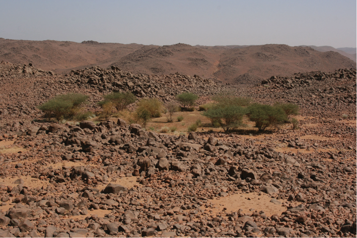
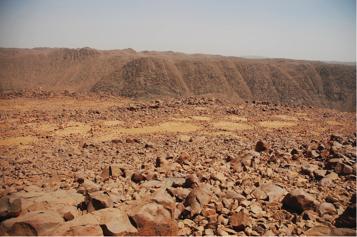
Jebel Sabaloka forms part of the Sabaloka Inlier, one of the best known Younger Granite Igneous complexes of the Sudan (Almond, Ahmed 1993). The dark, distinctly polygonal jebel (ca. 124 km2) rises above the surrounding dusty plains by ca 50 to 100 m and constitutes a prominent morphological feature in the relatively flat and monotonous terrain characteristic of Central Sudan. The mass of the jebel, formed of tough and resistant volcanic rocks of the ring complex, is sliced into two unequal parts by the Nile which passes through the mountains in a zig-zag gorge for a length of ca 15 km (see Figure 2). The two parts of the mountains on both banks of the Nile are dissected by several larger valleys (wadis) and smaller, steep-sided valleys (khors) into a system of plateaus at an altitude between 450 m and 550 m. The broad wadis are further dissected by smaller streams into numerous flat or gently inclined terraces and platforms. Unlike the slopes and plateaus of the jebel, bare and inhospitable at present, the wadis and khors still support meagre vegetation and allow for the grazing of animals (see Figure 3).
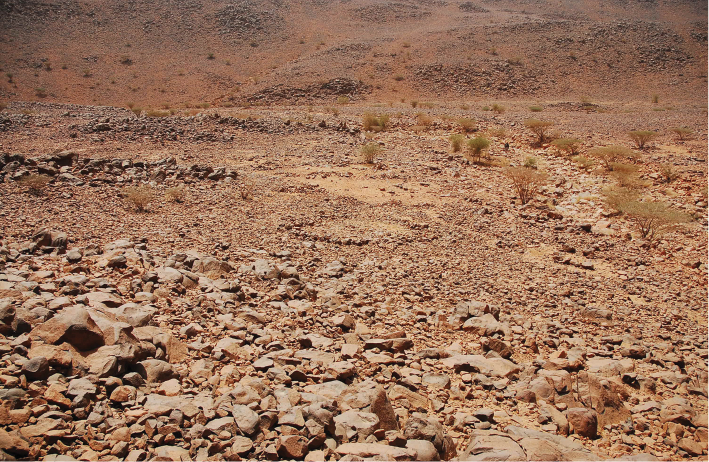
Before the Nile enters Jebel Sabaloka, the waters of the river divide into two branches to pass either side of Jazerat Wa‘arabyya (or Rauwiyan Island) located closer to the right bank of the Nile. The southern part of the island is dominated by the mesa-like mountain of Rauwiyan (594 m a. s. l.) the upper section of which is formed of strongly silicified tuffitic Nubian sandstones. This Nubian outlier rests partly on the wide screen of Basement gneisses and partly on the intrusions of the ring-dyke suite, which also characterises the landscape at the SW outskirts of the Sabaloka massif on the left bank of the Nile (Almond, Ahmed 1993, 35). In Sabaloka Gorge, the riverine landscape is little more than 0.5 km wide. The alluvial plain in the interior of the mountains is not continuous on either side of the river. It only occurs in small patches where the rocky slopes of the jebel recede from the banks. Slightly larger tracts of floodplain are located at the mouths of broad wadis on both banks of the Nile. They are used seasonally for limited cultivation and grazing of animals. Neither of the banks in Sabaloka Gorge is passable along its full length and the river constitutes the main artery of communication through the interior of the mountains. At the point where the Nile emerges from the constriction of the jebel, the river is once again split into two branches by the island of Miskit. In the right branch, the Sabaloka rapids – the smallest and the southernmost of the six Nile cataracts – punctuate the smooth flow of the Nile and constitute an obstacle for navigation.
3. Fieldwork
As no high-resolution topographical maps of the region and only limited archaeological reports concerning the Sabaloka research area were available, the programme of the landscape archaeological survey was prepared on the basis of Google Earth as the main source of data. Based on the detailed study of the images, several locations or features significant from the point of view of geomorphology, archaeology and landscape were selected in advance to be subsequently explored in the field. In addition to these, other parts of the research area were included into the programme in the course of the fieldwork in consequence of restrictions of access to some sections of the mountains imposed by the military officials from Jebel Irau3 and with a view to examine the remains of former human activities reported by the local inhabitants.
The sections of the Sabaloka research area subjected to the landscape archaeological survey are shown in Figure 1. They comprise representative sections of the following landscape units and environments occurring in this region:
1. The riverine landscape and slopes and plateaus of the mountains within Sabaloka Gorge (Figure 2).
2. The broad wadis that cut through the jebel (Figure 3).
3. The interior plateaus and outer periphery of the mountains (see Figure 2).
4. The SW outskirts of the mountains on the left bank of the Nile (Figure 4).
5. Rauwiyan Island (see Figure 4).
The landscape archaeological survey of the areas shown in Figure 1 was carried out in the course of nine days of the first field campaign (between 26 October and 6 November 2009) and ten days of the second field campaign (between 17 and 26 February 2011). The survey was performed by the authors of this paper and Murtada Bushara (archaeologist, NCAM inspector). This stable archaeological unit was accompanied during 2009 by Zaki Mustafa from the village of Miseiktab and at some occasions during both seasons by Lenka Lisá and Pavel Lisý otherwise engaged in the study of the Nile alluvial deposits within Sabaloka Gorge (see Lisá et al. 2012). The selected areas were criss-crossed or walked in lines by the members of the archaeological unit working independently and in a number of cases re-examined for the purposes of more detailed documentation. During the survey, the locations of all remains of former human occupation were recorded using a hand-held GPS. Surface features, artefacts, and landscape contexts were described and photographed. In certain cases, sketches and plans were drawn. No trial excavations were undertaken during this phase of the project. Where available, samples of pottery and other material were collected from the surface for the purposes of dating. Lithics were not studied systematically and only several pieces were collected along with samples of rocks from local outcrops for the purposes of study of distribution and utilisation of raw materials in the past. In addition, local names of hamlets, wadis, khors, hills, and various topographical features not marked on maps were ascertained and documented, together with stories and legends related to a number of them.4
4. Recorded sites and evidence and their landscape setting
Over the course of the survey, more than 300 points of interest were recorded, making up in total 138 locations with evidence of former human activity (Suková et al. 2010, 2011). The sites and evidence of occupation were dated on the basis of pottery and other surface finds. The dates span from the Palaeolithic up until the recent past. Twenty-eight locations indicate multi-period occupation during the prehistoric (Palaeolithic and Mesolithic/Neolithic) and historical (Meroitic/Post-Meroitic and Christian/Islamic) periods (see Table 1). The remains which could not be assigned with certainty to at least prehistoric or historical periods in general are presented in the table as uncertain.5 Where diagnostic material to allow attribution of the sites to a particular chronological unit within the two general periods was not available, the evidence is classified either as Prehistoric (unspecified, 10 locations) or Historical (unspecified, 76 locations). The occurrences of evidence per chronological units and landscape units are summarised in Table 2. The spatial distribution of prehistoric and historical sites and evidence is presented in Figures 5 and 6, respectively.
The evidence of former human occupation recorded during the survey can be divided into seven categories. In a number of cases, one and the same location was found to have been used for both settlement and burial purposes at different times. The distribution of the categories per landscape units is summarised in Table 3. The spatial distribution of six of the categories is shown in Figure 7.
4.1 Settlements
This category includes 8 sites of 3 different types:
1. A settlement with stone foundations of structures with well-defined rectangular, square, or circular ground-plans located among the small outcrops of the ring-dyke intrusion at the northern tip of Rauwiyan Island (Figure 8). On the basis of the surface finds, copious fragments of undecorated and decorated pottery and bricks, the settlement can be dated to the Christian and/or Islamic periods.
2. Five terraced “villages” in the riverine landscape of Sabaloka Gorge. These inconspicuous settlements are located on terraces on the slopes and on the top plateaus of the jebel on both banks of the Nile at intervals of approximately 2–3 km (Figure 9). The terraces and plateaus feature areas cleared of larger stones which are littered with evidence of former occupation. Remains of dwelling structures are absent, although stone features of two main types – low walls delimiting the settlement area and stone rings – were noted at two of these sites. The surface finds and features suggest a wider spectrum of activities that could have taken place at these sites. Moreover, their spatial distribution at the sites suggests a differentiation of areas within these settlements. The pottery and other types of finds (cf. Al-Sanjak 1978, 87–90; Elzein 2004, 70–73; Phillips 2003, 432–436; Taylor, Bieniada 2007, 116–117) allow for dating of the terraced “villages” to the Christian and Islamic periods.
3. Two prehistoric occupation sites in the rocky landscape of the ring-dyke intrusion at the SW outskirts of Jebel Sabaloka and on Rauwiyan Island. The density, extent, and variety of archaeological material observed at these sites suggest more intensive and long-lived occupation of these locations. This is the case, in particular, for site AD 11/13 at the SW outskirts of the mountains where extensive remains of midden-deposits packed with Mesolithic and Neolithic pottery, lithics, stone implements, and well-preserved bones of animals, fish, and shells of molluscs were identified at two of the numerous terraces of the large granite outcrop (Figure 10).6
4.2 Forts
The remains of two forts were examined in the riverine landscape of Sabaloka Gorge. One of these is a rectangular fort (circa 1,850 m2) located on the left bank of the Nile right at the Sixth Nile Cataract (Figure 11).7 The fort, preserved only in outline, once featured two gates (on the SW and NE sides), four projecting corner towers, and two projecting interval towers (on the NW and SE sides). The surface finds support the dating of this fort to the Medieval and Post-Medieval periods. The second fort of the same date, as suggested by the surface finds, was investigated on the right bank in the middle of Sabaloka Gorge. It was a small square building (circa 10×10 m) located right on the riverbank, with stone walls of dry masonry preserved on the side facing the Nile up to a height of 0.8–1 m. The fort appears to have stood at the terminus of several paths descending to the Nile from the interior and the periphery of the jebel. Clear views can be gained both upstream and downstream of this site over the straight section of the river in this part of Sabaloka Gorge.
4.3 Stone features and structures
At 28 locations, stone structures and features of varied types were recorded. These included 7 single occurrences of less common features and structures, such as surface accumulations or piles of stones on rectangular or sub-rectangular ground-plans of an uncertain purpose, “boundary wall”, linear and rectangular settings of stones (see Welsby 2005, 6), and a substantial stone ring (6 m) formed of large blocks and featuring two big stones in the interior (Figure 12). The remaining 21 locations yielded common types of stone features and structures related to settlement activities, such as the remains of stone foundations of wind-breaks, animal pens, and huts/shelters (see Borcowski, Welsby 2009). They were found either isolated or in clusters and concentrations of features of several types. In 7 cases, they were recorded at locations also used as burial grounds. These features abounded in particular in the wadis of the interior of the mountains (15 locations). The most interesting occurrence of these features was recorded in Wadi el-Kheyariya circa 1 km from the Nile on a terrace circa 60 m in length. The site featured cleared activity or occupation areas with several types of these stone structures. In addition, three graves with superstructures consisting of low mounds of stones resting on a matrix of sediments and a grand stone circle with an altar-like block situated above the three burials were noted at this location (Figure 13). Surface finds included scattered lithics of a Mesolithic/Neolithic date and diverse occupation debris, some attributable securely to the Late Meroitic and Post-Meroitic periods (Suková, Varadzin 2012a; cf. Wolf, Nowotnick 2005). The simple stone structures and camp sites of these types can still be encountered in use at present. They attest to a considerable conservatism as to the structures, building techniques and dwelling modes resorted to by herders, which most probably derives from practical concerns as well as from the local geology as the determining and restricting factor (Figure 14; see also Figure 3).
4.4 Cemeteries
In all 48 burial sites consisting of isolated grave monuments, clusters of graves (Figure 15), or extensive cemeteries with over 100 tumuli (Figure 16) or other types of graves were recorded in the diverse landscape units within the research area. The variety of locations and broad spectrum of superstructures suggests different dates of the cemeteries, with all of them falling into the historical periods. At the SW outskirts of Jebel Sabaloka, a number of Meroitic and/or Post-Meroitic tumuli were found in the lower areas occupied during the Mesolithic and Neolithic times by a seasonal lake and overgrown with shallow reeds and swamp vegetation. In the wadis, in contrast, simple stone cairns indicating burials were found on terraces also used for settlement purposes (see above, 4.3). While it may be possible that the settlement and funerary features noted in close proximity at a number of these terraces may be contemporary, it seems more probable that the close spatial relationship between these features is the result of use, reuse and alterations of the terrain by groups separated in time (cf. Wolf, Nowotnick 2006, 25).
4.5 Quarrying and mining sites
Eight quarrying and mining sites were recorded in the foot zone and on the slopes or plateaus of Jebel Rauwiyan. The chisel marks left behind by metal tools on the silicified sandstone blocks at five locations place the use of these quarries into historical to recent periods. Of an unknown date (prehistoric or historical), on the other hand, are the mining pits recorded on one of the platforms and on the summit of Jebel Rauwiyan. A prehistoric mining site was recorded at an outcrop of jasper-quartz dyke associated with the ring-dyke intrusion on the left bank of the Nile. In addition, a number of outcrops of rhyolite and trachybasalt, which could have served as sources of raw materials for the production of stone tools, were noted on Rauwiyan Island and at the SW outskirts of Jebel Sabaloka.
4.6 Water harvesting features
Two systems of water harvesting features were recorded on the top plateau of the mountains within Sabaloka Gorge (Figures 17, 18). Both were associated with the Christian and/or Islamic terraced “villages”.
4.7 Simple surface scatters
At 54 locations, simple surface scatters of lithics of varied date and pottery of diverse types and historical dates were recorded in all of the surveyed landscape units. They attest to either mere transient use of the locations, or indicate the presence of simple occupation sites undetectable without surface clearing and excavation.
5. Landscape units of Jebel Sabaloka and their characteristic settlement pattern
Based on the landscape archaeological reconnaissance of the research area, the significance of Jebel Sabaloka and its outskirts can be seen in the following:
1. Major Christian and Islamic settlements were located at both ends of the gorge where the river could be crossed by trade routes and easily controlled and protected by forts.
2. The steep rocky slopes of the mountains in Sabaloka Gorge provided the morphological basis for the construction of terraced “villages”, a settlement type of the Christian and Islamic periods, otherwise unknown in the Middle Nile region. These settlements are characteristically built on systems of terraces and plateaus located in the central or upper sections of the slopes. They are located above patchy tracts of alluvium, have an access (“port”) to the river and are approached via man-made paths. All command excellent views over the entire Sabaloka Gorge. This position implies a partial reliance of the occupants on the river for water and subsistence. Nevertheless, the presence of features for rainwater harvesting on the top of the plateaus above two of these settlements suggests that the occupants might have been forced to search for alternative sources as well (cf. Taylor, Bieniada 2007). We speculate that the position of the settlements was chosen both for better protection from the Nile Valley where intruders were most likely to come as well as with a view to the maximum exploitation of the limited agro-pastoral potential of the constricted riverine landscape and the hills above the Nile.
3. The inselbergs of the ring-dyke intrusion at the SW outskirts of Jebel Sabaloka hosts one of the richest Mesolithic and Neolithic settlements in the Middle Nile region. They constitute a prehistoric landscape par excellence in which elevated platforms and terraces on the local granite outcrops were ideal locations for occupation in a landscape overgrown by swamp vegetation, braided by channels and periodically submerged by the waters of the annual Nile floods during the Early and Middle Holocene.
From a geomorphological point of view, the following specific human significance of the diverse landscape units and their segments can be discerned on the basis of our fieldwork:
Nile floodplain: due to its young age (approx. only 2,000 years, see Lisá et al. 2012), it mostly contains remnants from the Christian and Islamic periods (Rauwiyan Island, large settlement of the Funj period at Qerri on the right bank to the south of Jebel Sabaloka).
Inselbergs of the ring-dyke intrusion: the Mesolithic and Neolithic settlement sites are characteristically located close to the river, but because the level of the Nile was circa 5 m higher during the Early and Middle Holocene as compared with present times (Arkell 1953), the occupation sites are concentrated on elevated rocky outcrops and around the inselbergs.
Entrances to the gorge: these represented crucial points for the Nile crossing and control of the river during Christian and Islamic times and were the locations of major settlements and forts. Finds of earlier periods attest to the occupation of these sites also during prehistoric times.
Riparian belt: the narrow and unevenly developed belt of arable land within Sabaloka Gorge features only structures of Christian and/or Islamic date. Several rocky spurs or lower sections of the slopes directly above the river (e.g., the rocky promontory below the terraced “village” on Figure 9) yielded small scatters of lithics of a Mesolithic or unspecified prehistoric date which suggest the occupation of these locales in connection with fishing or exploitation of other resources of the river during prehistoric times.
Slopes of the valley: apart from the series of terraced “villages” dated to the Christian and/or Islamic periods, the rocky slopes yielded only few remains of occupation during earlier times.
Jebel Sabaloka interior – valleys: these communications between the Nile in Sabaloka Gorge and the outskirts of the mountains were in all probability primarily used by herders who have left behind on the terraces numerous, mostly undated stone structures and discrete burial grounds. We envisage transient and polycyclic occupation of these locations.
Jebel Sabaloka interior – plateaus: only very limited evidence of former human occupation, primarily scatters of lithics of an unspecified prehistoric date, have been documented on the outer edges of the plateau and the periphery of the mountains in addition to two extensive tumuli fields and a small quarry site.
Rauwiyan Island: the area is significant from at least two points of view: (1) the highest mountain of the area is located there and represents the only place in the Sabaloka research area where silicified Nubian sandstone had been mined and quarried from the Middle Palaeolithic up to the historical periods; (2) the Medieval and/or Post-Medieval agglomeration in the northernmost part of the island is in all probability related to the fortified village at Jebel Irau which rises above the northern tip of the island further downstream on the right bank of the Nile (see Chittick 1963; Al-Sanjak 1978, 83–91).
Conclusions
During the first archaeological reconnaissance carried out at Jebel Sabaloka in two short field campaigns, evidence of former human occupation and land use was recorded in all of the main landscape units (Table 3). Several previously unsuspected site types and hitherto unreported periods of occupation were plotted on the regional archaeological map. Of great importance among these are in particular the Mesolithic and Neolithic settlements and occupation sites at the SW outskirts of the mountains and on Rauwiyan Island on account of which the area of Sabaloka may no longer be ignored in overviews of the late prehistory of Central Sudan (see Sadig 2009; Dittrich 2011). Furthermore, a more detailed exploration of the complex system of Christian and Islamic settlements, forts, and occupation sites detected in this area may shed more light on life at the internal periphery within the large Medieval and Post-Medieval realms and the hitherto little understood period of transition between the Christian kingdom of Alwa and the Islamic (Funj) rule as well as on the more recent history of Central Sudan.
This presentation of the findings of the first landscape archaeological reconnaissance at Jebel Sabaloka has been derived from the necessity to draw attention to the archaeological evidence and the specificity of the environments of this area which will soon be affected by the planned construction of a dam at the Sixth Nile Cataract. There are only six series of rapids on the Main Nile of which the Sixth Cataract had represented the last hitherto almost archaeologically unknown area in spite of its close vicinity to Khartoum. The primary result of the Czech research at Jebel Sabaloka is consequently the first discovery of a surprisingly complex, dense, and polycyclic network of previously unknown sites. After the first two seasons in this region it can be stated that the last uninvestigated Nile Cataract has finally begun to reveal its rich and unknown archaeological past.
Acknowledgements
We would like to thank the staff of the National Corporation for Antiquities and Museums for their assistance and support rendered in connection with the geoarchaeological research at Jebel Sabaloka. This study was supported by the Charles University Scientific development programme No. 14: Archaeology of non-European areas, Sub-project: Ancient Egyptian civilisation research: cultural and political adaptations of the North African civilisations in Antiquity (5000 BCE–1000 AD), and by the RVO 67985831 project of the Institute of Geology (AS CR, v. v. i.).
References
ALMOND, D. C., AHMED, F. 1993: Field Guide to the Geology of the Sabaloka Inlier, Central Sudan. Khartoum University Press, Khartoum.
Arkell, A. J. 1949: Early Khartoum. An account of the excavation of an early occupation site carried out by the Sudan Government Antiquities Service in 1944–5. Oxford University Press, London, New York, Toronto.
ARKELL, A. J. 1953: Shaheinab. An Account of the Excavation of a Neolithic Occupation Site Carried Out for the Sudan Antiquities Service in 1949–1950. Oxford University Press, London, New York, Toronto.
BORCOWSKI, Z., WELSBY, D. A. 2009: The Merowe Dam Archaeological Salvage Project: Provisional type series of monuments, on-line: http://www.nubiansociety.org/PDF/MDASP/MDASP-TypeSeries12-09.pdf (accessed in May 2012).
CHITTICK, H. N. 1963: The Last Christian Stronghold in the Sudan, Kush XI, 264–272.
EDWARDS, D. N. 2004: The Nubian Past: An Archaeology of the Sudan. Routledge, London, New York.
ELZEIN, I. S. 2004: Islamic Archaeology in the Sudan. BAR International Series 1289, Archaeopress, Oxford.
DITTRICH, A. 2011: Zur Neolithisierung des Mittleren Niltals und angrenzender Regionen: Kultureller Wandel vom Mesolithikum zum Neolithikum im Nord- und Zentralsudan. BAR International Series 2281, Archaeopress, Oxford.
GATTO, M. C. 2006–2007: “Je voudrais te montrer un truc”. A short note on a possible A-Group related cemetery at the Sixth Cataract of the Nile (Sudan), CRIPEL 26, 115–117.
HAALAND, R. 1982: Migratory Herdsmen and Cultivating Women. The Structure of Neolithic Seasonal Adaptations in the Khartoum Nile Environment. Universitetet i Bergen, Bergen.
LISÁ, L., LISÝ, P., CHADIMA, M., ČEJCHAN, P., BAJER, A., CÍLEK, V., SUKOVÁ, L., SCHNABL, P. 2012: Microfacies description linked to the magnetic and non-magnetic proxy as a promising environmental tool: Case study from alluvial deposits of the Nile river, Quaternary International 266, 25–33.
PANER, H. 1997: Brief Report on the Work of the Gdańsk Archaeological Museum Expedition (GAME) in the Sudan (1993–1997). In: Orbis Aethiopicus – Ethiopia and Its Neighbours. Frankfurt, 59–74.
PHILIPS, J. 2003: An Overview of the Ceramics. In: Żurawski, B. (Ed.): Southern Dongola Reach Survey, Vol. 1., Survey and excavation between Old Dongola and Ez-Zuma. Research Centre for Mediterranean Archaeology of the Polish Academy of Science, Warszawa, 387–437.
SADIG, A. M. 2009: Preliminary Observation on the Neolithic Settlement Patterns in Central Sudan, Sahara 20, 31–56.
AL-SANJAK, H. A. 1978: An Archaeological Survey between Rauwiyan and Jebel Qerri Stations from the Railway Line to the Nile. MS. Ba (Hons) Dissertation. Deposited: Department of Archaeology, University of Khartoum.
SUKOVÁ, L., CÍLEK, V., LISÁ, L., LISÝ, P., BUSHARA, M. 2010: Report on the Geoarchaeological Survey in the Area of Sabaloka, the Sixth Nile Cataract, Sudan, Studia Oecologica III, 40–53.
SUKOVÁ, L., CÍLEK, V., BUSHARA, M. 2011: Geoarchaeological Research in the area of Sabaloka and the Sixth Nile Cataract (February 17–26, 2011): Detailed Archaeological Report. Unpublished fieldwork report for the NCAM. Deposited: Archives of the Czech Institute of Egyptology, Faculty of Arts, Charles University in Prague.
SUKOVÁ, L., VARADZIN, L. 2012a: Preliminary report on the exploration of Jebel Sabaloka (West Bank), 2009–2012, Sudan & Nubia 16, 118–131.
SUKOVÁ, L., VARADZIN, L. 2012b: Sabaloka Dam Archaeological Salvage Project: Výzkum pravěkého osídlení v pohoří Sabaloka v centrálním Súdánu, Pražské egyptologické studie IX, 3–10.
TAYLOR, H., BIENIADA, M. 2007: Archaeological Reconnaissance in the Nuba Mountains, Sudan, Sudan & Nubia 11, 112–118.
WELSBY, D. A. 2005: The Merowe Dam Archaeological Salvage Project: Survey in the vicinity of ed-Doma (AKSE), 2004–2005, Sudan & Nubia 9, 2–8.
WOLF, P., NOWOTNICK, U. 2005: The Second Season of the SARS Anglo-German Expedition to the Fourth Cataract, Sudan & Nubia 9, 23–31.
WOLF, P., NOWOTNICK, U. 2006: The Third Season of the SARS Anglo-German Expedition to the Fourth Cataract, Sudan & Nubia 10, 20–32.
*Corresponding author. E-mail: sukova.lenka@gmail.com
1For previous accounts on the archaeological evidence in the research area, deriving from limited reconnaissance or survey work mostly on the right bank of the Nile, see Arkell (1949, 116; 1953, vii, 108), Chittick (1963), Al-Sanjak (1978), Paner (1997, 59–60), Elzein (2004), and Gatto (2006–2007).
2The research undertaken during the first two seasons was financed from the funds of the Grant Agency of Charles University (project No. GAUK 15009), Academy of Sciences of the Czech Republic (projects No. M100130902 and AV0 Z 30130516), and the Ministry of Education, Youth, and Sports of the Czech Republic (project No. MSM 0021620826).
3The restrictions of access concerned the interior of the mountains on the right bank of the Nile where a military zone had been established.
4In 2009, the most important informant was Zaki Mustafa from the village of Miseiktab.
5This is the case of the man-made mining pits on Jebel Rauwiyan.
6See Suková and Varadzin (2012a, 2012b) for an evaluation of the significance of this site (the “Fox Hill”) resulting from the in-depth exploration of the prehistoric landscapes of the left bank of the Nile since the autumn of 2011.
7This fort is mentioned already by Al-Sanjak in his description of the Mahdiya tabya and the small stone fort a little upstream of the Sixth Nile Cataract on the right bank of the Nile, see Al-Sanjak (1978, 81–83).
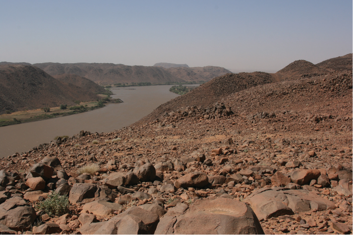
Figure 1. Jebel Sabaloka and the Sixth Nile Cataract: the ovals/circles indicate the sections of the research area subjected to a landscape archaeological survey during the first two field campaigns (2009 and 2011); the numbers enclosed within the ovals/circles (1–5) refer to the five distinct landscape units and environments differentiated within the research area (background: Google Earth 2012).
Figure 2. The Nile and the constricted riverine landscape within Sabaloka Gorge and the bare and inhospitable plateaus of the jebel; the sandstone mesa-like mountain of Rauwiyan can be seen in a distance above the plateau of the Sabaloka massif (photo L. Suková).
Figure 3. Present-day pastoral landscape in the wadis of Jebel Sabaloka on the left bank of the Nile (photo L. Suková).
Figure 4. View over the granite outcrops in the ring-dyke intrusion at the SW outskirts of Jebel Sabaloka on the left bank of the Nile towards the mesa-like sandstone mountain of Rauwiyan which dominates the island of Jazerat Wa‘arabyya and overlies in part the rocky fields of the ring-dyke intrusion and the low-level desert of the Basement Complex (photo L. Suková).
Figure 5. Prehistoric sites identified in the surveyed landscape units: white – Palaeolithic, red – Mesolithic/Neolithic, yellow – Prehistoric (unspecified); larger dots indicate sites of significance – major settlement sites (background: Google Earth 2012).
Figure 6. Historical sites identified in the surveyed landscape units: white – Meroitic/Post-Meroitic, red – Christian/Islamic, yellow – Historical (unspecified), black – uncertain; larger dots indicate sites of significance – major settlement sites, forts, and cemeteries (background: Google Earth 2012).
Figure 7. Spatial distribution of the categories of evidence of former human occupation recorded in the surveyed landscape units: red – settlements, yellow – forts, grey – stone structures and features (simple occupation/camp sites), white – cemeteries or single graves, green – quarrying and mining sites, blue – rainwater harvesting features; simple scatters of lithics and/or pottery are not represented (background: Google Earth 2012).
Figure 8. Collapsed small building on a square ground-plan (a tower?) situated on the side of a straight-lined path that passes by the settlement of the Christian/Islamic period in the northern part of Rauwiyan Island (view towards east) (photo L. Suková).
Figure 9. One of the terraced “villages” located on a system of terraces in the steep rocky slopes of Sabaloka Gorge; a larger agglomeration of this type, with an extensive system of rainwater harvesting features above the main occupation area, is located on the left bank of the Nile, opposite this minor “village” (photo L. Suková).
Figure 10. View of one of the occupation terraces and platforms at the richest and most complex Mesolithic and Neolithic settlement of the entire research area located at the SW outskirts of Jebel Sabaloka; in addition to a dense scatter of lithics, potsherds, stone implements and other material, grinding hollows were noted on upper surfaces of the exposed bedrock (photo L. Suková).
Figure 11. Remains of the Christian/Islamic period fortress at Wad Mukhtar on the left bank of the Nile at the Sixth Nile Cataract (view towards east) (photo L. Suková).
Figure 12. Substantial stone ring with two huge blocks in the interior on the left bank of the Nile within Sabaloka Gorge; it was located on a spur which formed the lowermost level of the large Christian and Islamic agglomeration that occupied the slopes and plateau of the mountains and was associated with an extensive linear system of rainwater harvesting features (photo L. Suková).
Figure 13. View (from north) of the remains of an occupation (camp) site on one of the terraces in the wadis in the interior of the mountains, with a large stone ring (centre), a low-walled circular feature (foundations of an animal pen), 3 small graves on the edge of the central occupation area, and parallel rows of stones (right centre) (photo L. Suková).
Figure 14. Campsite of modern nomads located among the picturesque granite outcrops at the western foot of Jebel Sabaloka, with an occupation area cleared of all stones and gravel, delimited area of an animal enclosure, several clusters of large stones (stone features), and huts of wood, branches and palm fronds (photo L. Varadzin).
Figure 15. One of the 16 cemeteries recorded at the SW outskirts of Jebel Sabaloka; the cluster of Meroitic/Post-Meroitic tumuli is located on one of the terraces intensively occupied during the Mesolithic and Neolithic times; the superstructures of two of the tumuli are in the form of large (9m in diameter) mounds heaped up from the remains of the prehistoric midden-deposit and capped with loose blocks of the local granite (photo L. Suková).
Figure 16. Some of more than 100 tumuli of the most extensive Meroitic/Post-Meroitic cemetery in the research area; the tumuli with superstructures in the form of stone mounds (up to 3 m in height), well-visible on Google Earth, dot the gently inclined pediment above the large wash-cone in the NW corner of Jebel Sabaloka (photo L. Suková).
Figure 17. Cistern overgrown by acacias and grasses recorded on the plateau above the main occupation area of the terraced “village” at Wad Abu Agib (photo L. Suková).
Figure 18. One of the three linear series of rainwater harvesting features or catchment areas recorded above the occupation area of the terraced “village” at Wad el-Hajj (photo L. Suková).


Table 1. Chronological units of the Holocene history of the Sudan represented in the archaeological record of the Sabaloka research area (time spans based on Edwards 2004).
|
Chronological unit |
Time span |
|
Islamic (“Post-Medieval”, Funj) period |
ca. AD 1500–1900 |
|
Christian (“Medieval”) period |
ca. AD 550–1500 |
|
Post-Meroitic period |
ca. AD 350–550 |
|
Meroitic period |
ca. 300 BC–AD 350 |
|
Neolithic period |
ca. 5000–3000 BC |
|
Mesolithic period |
ca. 10000–5000 BC |
Table 2. Occurrences of prehistoric and historical evidence per landscape units.
|
Landscape unit / Number of occurrences |
Palaeolithic |
Mesolithic / Neolithic |
Prehistoric (unspecified) |
Meroitic / Post-Meroitic |
Christian / Islamic |
Historical (unspecified) |
Uncertain |
Prehistoric + Historical |
|
1. Sabaloka Gorge (riverine landscape, slopes, plateaus) |
0 |
6 |
3 |
1 |
12 |
5 |
0 |
8 |
|
2. Wadis (el-Kheyariya and Asunut) |
0 |
3 |
0 |
1 |
0 |
28 |
0 |
2 |
|
3. Interior plateau and periphery of the mountains |
0 |
1 |
3 |
2 |
0 |
3 |
0 |
1 |
|
4. SW outskirts of the mountains |
0 |
15 |
2 |
14 |
0 |
4 |
0 |
9 |
|
5. Rauwiyan Island |
7 |
20 |
2 |
4 |
3 |
36 |
2 |
8 |
|
Total |
7 |
45 |
10 |
22 |
15 |
76 |
2 |
28 |
Table 3. Categories of sites and evidence per landscape units.
|
Landscape unit / Category of site and evidence |
Settlements |
Forts |
Stone structures and features |
Cemeteries |
Quarrying and mining sites |
Rainwater harvesting features |
Simple surface scatters |
|
1. Sabaloka Gorge (riverine landscape, slopes, plateaus) |
5 |
2 |
3 |
1 |
0 |
2 |
5 |
|
2. Wadis (el-Kheyariya and Asunut) |
0 |
0 |
15 |
20 |
0 |
0 |
1 |
|
3. Interior plateau and periphery of the mountains |
0 |
0 |
1 |
4 |
1 |
0 |
1 |
|
4. SW outskirts of the mountains |
1 |
0 |
2 |
16 |
0 |
0 |
7 |
|
5. Rauwiyan Island |
2 |
0 |
7 |
7 |
8 |
0 |
40 |
|
Total |
8 |
2 |
28 |
48 |
9 |
2 |
54 |