Volume I ● Issue 1–2/2010 ● Pages 91–97
News and Views
An Unusual 10th Century Female Burial from Denisova Street in Olomouc
Richard Zatloukala, Michal Živnýb
aNational Institute of the Care of Monuments – the territorial specialized department in Olomouc, Horní náměstí 25, 771 11 Olomouc, Czech Republic
bInstitute of Biology and Ecology, Faculty of Science, Ostrava University, 30. dubna 22, 701 03 Ostrava, Czech Republic
Abstract
The technical infrastructure of Denisova Street, one of the busiest business and traffic thoroughfares in the city of Olomouc, has been in poor condition for quite some time. The municipality initiated a general reconstruction, followed by an archaeological rescue excavation. The removal of pavement and the uncovering of a gravel-sand layer, was followed by the mechanical levelling of shallow-lying bedrock. The area appeared to be archaeologically negative until May 11 when a backhoe shovel contacted a human skeleton. The skeleton rested not just under the contemporary roadway, facing the entrance of Our Lady of the Snows Church (Figure 1, the pit S 66). The corpse (context 452) lay on its abdomen. During the preparation of the skeleton, we detected post-mortem manipulation, as the right hand (or more precisely the palm with fingers) was missing and found later under the skull together with the left hand. Likewise, the feet were missing due to their destruction by recent gas pipeline excavation. The skull was also significantly disturbed when uncovered by construction equipment. Through anthropological analysis we determined that the skeleton is the remains of a female who probably died at over 50 years of age. Her height was between 145–155 cm (low to middle height). The grave can be dated to the end of the 10th century on the basis of pottery fragments found in the grave fill (Figure 6).
The original burial must have been opened within several months after burial, for unknown reasons, and subsequently some body parts, or the entire dead body, were removed to a new grave site. During transportation, the partially decomposed body was probably disturbed so that it would have likely been transferred in an appropriate case. The body could also have been placed in the grave pit by simply being thrown from a stretcher.
Considering that the reason for the putative transfer of the body was not found in the field of the natural sciences, we will probably have to look for it within the sphere of social relationships within the society of medieval Olomouc.
Article history
Received: 15 December 2010
Accepted: 16 March 2011
Key words
unusual female burial
10th century
Olomouc
1. Research conditions and excavation method in Denisova Street
Denisova Street, along with the adjacent Náměstí Republiky (Republic Square) and Pekařská Street, is counted among the busiest business and traffic thoroughfares of the city of Olomouc. The poor condition of these streets required thorough reconstruction (Figure 1) comprising the renovation or replacement of sewer pipes, ducts, gas pipelines, roads, tram rails and trolley wire. Since all of the above mentioned subsurface work had already been completed on the streets, archaeologists were only able to record and samples from sections of select ditch walls. Considering the complications of the concurrent construction and excavation work, we ruled out the possibility of prior manual archaeological excavation by probes. Digging would have taken place in older trenches, and the archaeological benefit from such probes would be compromised. The main sewer, running down the middle of the street, was renewed using special inserts, and was not uncovered at all. Connections to building gas and water pipes were replaced, however, new ditches were dug through old. Naturally, the new construction excavations did not copy the old ditches completely, but it was not technically or organisationally possible to perform manual archaeological excavations. Due to concerns about building stability and safety the walls of single ditches were being supported by trench boxes, and only the gaps between these boxes were available for recording. Even these column sections, often just a few decimetres wide, were significant in reconstructing the general view of the relief of the medieval terrain. As construction works usually began with the dismantling of pavement, tram roadway and underlying absorption bed, some 0.3 m thick, the sections were normally recorded from this lowered level (with some exceptions). Of 454 metres of renovated municipal pipeline, 91.1 metres in 68 sections were recorded.
2. Geological description of investigated area
The entire historical core of Olomouc, including the Premyslid castle and surrounding area, is situated on Olomouc Hill – a rather ragged, horseshoe-shaped formation. The dominant features are Michal Hill (233 m, above sea level), Peter Hill (225 m, a.s.l.) and Wenceslaus Hill (226 m a.s.l.). The western part of the Olomouc Hill descends slowly, whereas the eastern part falls sharply into the alluvial plain of the Morava River.
Náměstí Republiky (Republic Square) lies at the west end of the castle area and slopes down to the northwest. At its south end a fault runs between Peter Hill and Wenceslaus Hill. Local bedrock is formed by culmian greywackes, interlaid with conglomerates, superimposed by Tertiary fluvial sands, denominated as context n. 107 throughout the site. The bedrock rises towards the surface from east to west so that at the mouth of Denisova Street it lies straight under the road (224.5 m a.s.l.). The rock rises virtually to the surface throughout the entire length of Denisova Street so that archaeological finds are scarce here, and restricted to those places where rock had been disturbed and filled with anthropogenic materials. Another tectonic boundary between Peter Hill and Michal Hill lies at the intersection of Denisova, Ztracená, Ostružnická and Pekarska streets, the SW part of Michal Hill (up to Pekarska street) being significantly lowered and overlaid by Neogene sediments – calcareous clays and Pliocene to Pleistocene fluvial sands (Zapletal 2005, 10–15).
3. Description of the archaeological situation
The area of Denisova Street investigated in this excavation was archaeologically documented in 2001, in the course of a pipeline trench excavation (Dehnerová 2002, 80–81;
2004).
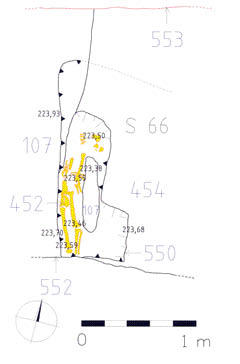
After dismantling the pavement and removing the absorption bed, the shallow-lying bedrock was mechanically levelled. The area seemed to be archaeologically negative until the backhoe dipper struck a human skeleton on May 11. The skeleton lay just under the road, in front of the entrance to the Our Lady of the Snows church (Figure 1, probe S66). Under significant time pressure the skeleton was prepared, recorded and removed (Figure 2). The deceased (context 452) had been deposited in the pit n. 550, dug in the bedrock k. 107, either in prone position or something similar to a crouched position (Figure 3). The body lay with its head to the north and feet to the south, with a slight deviation to NNE by SSW. The position of the skeleton indicated a rather uncommon primary placement or secondary position change (Figure 4). Moreover, during the excavation some post-mortem manipulations became obvious, as part of the right hand was missing, more specifically, the palm and fingers, which were found together with the left hand under the skull. The right arm lay along the body, bent at a right angle at the elbow such that the forearm was driven straight into the ground. The left arm was disarticulated at the elbow so that the arm lay along the body, whereas the forearm with the palm was turned in the angle of 180° towards the skull. The lower extremities were slightly bent at the knees. Both feet were missing, disturbed by a recent trench (c. 552) dug for a cast iron duct. In the course of mechanical construction work the skull had been disturbed as well. The scattered remaining fragments of the skull did not allow reconstruction of the head’s original position i.e. whether or not it lay face down.
The fill (c. 453) of the grave pit (c. 550) could not be distinguished from the surrounding layer c. 454. In both cases it was dark grey dusty soil. The differentiation was purely formal and context 453 represents the fill around the skeleton c. 452. The contour of the grave pit (c. 550), with N-S orientation, was postulated from the man-made lowering of the terrain (to under 223.7 m). Moreover, the grave pit had been disturbed at its southern end by a recent trench (c. 552). Only its sharp vertical western edge was well defined – its southern and northern ends were virtually invisible. The size of the pit is approximately 1.25 in length, 0.4 m in width, 0.4 m in depth. The bottom level, formed by unweathered bedrock (c. 107) lies at 223.32 m. Around pit c. 550 the bedrock reaches all the way to the foundations of the recent road (224.5 m above sea level), without traces of disturbance except natural weathering. Thus we may proclaim the pit c. 550 to be man-made and not the result of natural geological processes.
In other parts of Denisova Street the bedrock reached up to just under the present-day surface so that we documented only the relief of the natural altitude and one Bronze Age feature in probe n. 17 (Figure 1).
4. Dating
No artefacts found in context 453 can be classified as grave goods. Objects within the pit are secondary inclusions within the grave fill. The same can be said about context 454. 23 pottery fragments, three pieces of burned clay and an animal bone were found in context 453. Five of the pottery shards come from the 10th century, 18 pieces belong to the Bronze Age, out of which 3 belong to the Maďarovce-Věteřov Culture. 21 pottery fragments and 12 pieces of animal bones were found in context 454. Among the shards there are 12 pieces from the 10th century (Figure 6) and 9 pieces from the Bronze Age. On the basis of pottery analysis from the grave fill and its surroundings (contexts 453 & 454) we can date the grave to the end of the 10th century.
5. Anthropological analyses
5.1 Material
The state of preservation of the skeleton was partially affected by the disruptive excavation related to duct construction in the 20th century (the cause of the missing feet), but above all by natural disintegration.
5.2 Method
Skeletal remains were thoroughly anthropologically analyzed. Age and sex were estimated, morphoscopic and pathological marks were evaluated, and metric analysis, including height estimation, were made. Almost all anthropological analyses were made on the basis of the methods and criteria mentioned in Stloukal’s work (Stloukal et al. 1999).
5.3 Results
5.3.1 Preservation
The degree of preservation of the skeleton can be evaluated as medium, the state of skeletal remains, however, differs by part (as demonstrated graphically by Figure 7).
– The skull: Neurocranium was preserved rather poorly. Preserved parts include squamae of the frontal bone and adjoining parietal bones, and major parts of the temporal bones. The preserved parts of the facial skeleton of the skull include a rather well preserved lower jaw and both zygomatic bones, very fragmented upper jaw and remaining parts of the face.
– The teeth: teeth were rather incomplete and included the left upper canine, right lower premolar, right upper molar and all second molars. The teeth were still imbedded in their sockets.
– The torso: The spine was preserved relatively well, but only within the range of presacral vertebrae (preserved all almost completely); from the 5th lumber vertebra, inclusive, the vertebrae are missing in the caudal direction. Ribs were very fragmentary. The remains of the sternum include the manubrium and a part of the body of the bone.
– Upper extremities: The bones of the shoulder girdle were preserved in fragmentary condition. Arm and forearm bones, however, were preserved almost completely. Of the hand bones, all left wrist bones were preserved, and all metacarpal bones and proximal phalanges of both extremities were preserved.
– Lower extremities: The bones of the pelvic girdle were preserved in fragmentary condition (the preserved parts include a major part of the right ala ossis ilium and parts of the left pelvic bone). Both thigh bones were preserved almost completely. There are fragments of the right lower leg but none for the left. Foot bones were not preserved.
5.3.2 Sex estimation
The estimation of sex was made by morphoscopic and metric methods. Above all it was the evaluation of characteristic marks on preserved parts of the skull and the pelvis (Acsádi-Nemeskéri 1970), which show clear female marks (above all the character of such skull features as processus mastoideus, glabella and arcus superciliares, and such pelvic features such as sulcus praeauricularis with marked after-birth changes, and incisura ischiadica major). Furthermore, some metrical characteristics of long bones, most importantly of the right humerus (Černý 1971), were used for sex estimation. Measurements correspond to female or hyperfemale values (in hypothetical scale within the number 1 as 100% male sex and –1 as 100% female sex, the value for our humerus is approximately –0.9 based on used method). Based on these data the skeletal remains are almost certainly female.
5.3.3 Age estimation
Age estimation was rather complicated due to the poor preservation of age-specific skeletal components. Teeth abrasion estimates (Lovejoy 1985) were used predominantly, and showed an age above 50. This is in accordance with preserved parts of cranial sutures. Thus we are dealing with the skeletal remains of an individual deceased within the age category of maturus II – senilis (50–60 years of age). Current anthropological methods, however, fail to diagnose precisely the age of death in the case of individuals of more than 30 years of age, when dealing with skeletal remains. The given age estimation is thus rather approximate, and may in fact be lower (Brůžek 2008, 331).
5.3.4 Body height
Estimation of height was made on the basis of long bone measurements (Sjøvold 1990). Measured values range between 145 and 155 cm, most often between 148 and 152 cm. The skeletal remains thus belong to a female of low or middle stature.
5.3.5 Pathologies
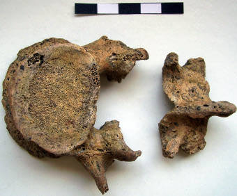
Skeletal remains did not reveal any marked anomalies or pathologies. We diagnosed only a congenital bilateral interarticular spondylolysis of the 4th vertebra, i.e. bilateral permanent separation of the vertebral arch from the body of the vertebra between upper and lower articular processes (Figure 8). This anomaly could be caused by stress factors influencing the spine during the life of individuum and has no relation to burial practices.
6. Discussion
Archaeological context 452 from Denisova Street in Olomouc contained skeletal remains of a woman of low to middle stature, deceased probably in the 10th century, most likely at the age of around 50. The unusual position of skeletal remains and the isolation of the grave indicate a rather uncommon burial, the kind usually connected with preventative measures against vampirism or revenance. Although we would like to avoid such hypothesis, we are unable to do so. As the skeleton does not bear traces of intentional disarticulation of joints, and yet the hands lay in non-anatomical position, we have to conclude their removal after natural disarticulation. Joint connection of the hand is classified as weak, and its disarticulation occurs as early as a few weeks after the deposition of the remains into the ground (Prokeš 2007, 17). For unknown reason the grave had to be re- opened soon (within a few months) after the burial. Subsequently, some body parts, or more likely, the entire body was transferred to another place. The disturbance of the partially decomposed corpse probably took place during this transport. Assuming the body needed to be transported in an appropriate case, the changes to the body might have gone unnoticed or nobody paid attention to them. The same reasons could have led to the disposal of the body into the new grave in its non-anatomical position, for example by simply throwing the corpse from a stretcher into the grave pit.
Considering that we could not find a reason of the supposed transfer of the body by means of natural science investigation, we must look to the social context of the medieval city of Olomouc.
Acknowledgement
This study has been written under the terms of the research plan MK n. 075 032 333 03, “Analysis and evaluation of archaeological rescue excavations of immovable monuments and areas of cultural heritage as new sources of knowledge of the history of the Czech Republic”.
References
ACSÁDI, G., NEMESKÉRI, J. 1970: History of human life span and mortality. Akadémiai Kiadó. Budapest.
BRŮŽEK, J. 2008: Současná česká paleodemografie: falešné naděje přílišného optimismu a nový reálný cíl. Archeologické rozhledy, 60, s. 329–343.
ČERNÝ, M. 1971: Určování pohlaví podle postkraniálního skeletu. In: Vlček, E. (Ed.): Symposium o určování stáří a pohlaví jedince na základě studia kostry. Národní muzeum v Praze, Praha, 46–62.
DEHNEROVÁ, H. 2002: Olomouc, ulice Univerzitní – Denisova – náměstí Republiky. In: Památkový ústav v Olomouci, Výroční zpráva 2001. Olomouc, 80–81.
DEHNEROVÁ, H. 2004: Olomouc, ulice Univerzitní, Denisova, náměstí Republiky, září–říjen 2001, číslo akce 68/01. Excavation report. Deposited: Archive of the National Monument Protection Institute Olomouc.
LOVEJOY, C. O. 1985: Dental Wear in the Libben Population: Its Pattern and Role in the Determination of Adult Skeletal Age at Death. American Journal of Physical Anthropology 68/1, 47–56.
PROKEŠ, L. 2007: Posmrtné změny a jejich význam při interpretaci pohřebního ritu (ke vztahu mezi archeologií a forenzními vědami). Archeologia mediaevalis Moravica et Silesiana, Supplementum 1, Brno.
SJØVOLD, T. 1990: Estimation of stature from long bones utilizing the line of organic correlation. Human Evolution 5/5, 431–447.
STLOUKAL, M. et al. 1999: Antropologie. Příručka pro studium kostry. Národní muzeum, Praha.
ZAPLETAL, J. 2005: Geologie historické části města Olomouce (tzv.Olomoucký kopec), Zprávy Vlastivědného muzea v Olomouci, 283,
10–18.
*Corresponding author. E-mail: zatloukal@olomouc.npu.cz

Figure 1. Olomouc, Denisova Street, general plan of the excavated area on cadastral map, with location of pit S 66.
Figure 2. Olomouc, Denisova Street, general view of excavation pit S 66 (photo J. Grégr).
Figure 3. Olomouc, Denisova Street, ground plan of excavation pit S 66.
Figure 4. Olomouc, Denisova Street, view from the east on preparation of grave c. 454 (photo R. Zatloukal).
Figure 5. Olomouc, Denisova Street, view from the north on preparation of grave c. 454 (photo R. Zatloukal).
Figure 6. Olomouc, Denisova Street, a sample of 10th century pottery from context c. 454 (drawing by M. Schindlerová).
Figure 7. State of skeleton preservation and integrity (drawing by M. Živný; used diagram: © M. Schultz, Zentrum Anatomie, Göttingen).
Figure 8. Lumbar vertebra with spondylolysis (photo M. Živný).
0 25 m


0 1 m


0 5 cm

0 10 cm