Volume I ● Issue 1–2/2010 ● Pages 29–36
Some Results of the Application of a Complex Approach to the Research of the Late Bronze Age Muradymovo Settlement in the Volgo-Ural Region
Nickolay Sherbakova*, Iia Shutelevaa, Gulnara Obydennovaa, Marina Balonovaa, Olga Khohlovab, Alexandra Golyevac
aArchaeological Laboratory of Bashkir State Pedagogical University, Ufa, Russia
bInstitute of Physicochemical and Biological Problems of Soil Science (Pushchino Scientific Centre), Russia
cInstitute of geography Russian Academy of Science, Moscow, Russia
Abstract
Research at the Late Bronze Age Muradymovo settlement site located in the Volga-Urals (Figure 1) is the first experience of a comprehensive study of archaeological materials with the help of natural sciences and techniques, such as paleopedology and radiocarbon dating (Chernykh et al. 2002; Chernykh et al. 2004). Radiocarbon dating of the Muradymovo settlement materials provided satisfactory results for ceramic samples. It also demonstrated the necessity of careful selection of cultural layer soils for dating purposes.
Article info
Article history:
Received: 6 December 2010
Accepted: 21 February 2011
Keywords:
palaeopedology
microbiomorphic analysis
radiocarbon dating
settlement, late Bronze Age
Volgo-Ural region
Srubno-Alakul’ culture
1. Introduction
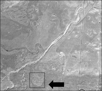
The Muradymovo settlement was discovered in 1990 by members of the expedition of the Bashkir Scientific Center of the Russian Academy of Science (Ufa), headed by A. Pshenichnyuk. From 1991 to 2009 an expedition from the Archaeological Laboratory of Bashkir State Pedagogical University excavated the settlement site. Between 1999 and 2007 the site was considerably damaged by plowing. In the north-western area of the site pockets of soil erosion resulted from the permanent pasturing of cattle (Figures 3 and 4). In addition, the Urshak River began to change its course because a farm had been built three kilometres to the south of the site (Figures 3 and 4). The settlement is situated on the banks of the Urshak River and this has led to the partial erosion of the site. The area of the site subject to flooding and bogging was excavated between 2000 and 2007 (Figure 5). Today, this settlement is one of the most completely excavated and researched sites in the central Volgo-Urals region (Figures 1 and 2).
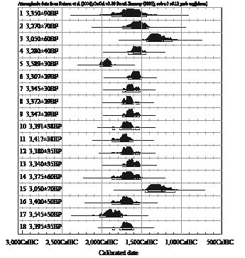
However, radiocarbon dating has never been used in studies of the Bronze Age settlements in the Bashkortostan territory (Hanks et al. 2007). The goal of resuming work on the Muradymovo settlement was to undertake a comprehensive study of material remains using the methods of the natural sciences (palaopedology, microbiomorphic analysis, radiocarbon dating) (Golyeva 2008; Golyeva et al. 2010). A second aim was to protect the site. Radiocarbon dating was done in the radiocarbon laboratory of the Institute of Environmental Geochemistry, National Academy of Science (NAS) of Ukraine, Kiev (Kovaluh, Skripkin 2008). Radiocarbon dating of the materials of the Muradymovo settlement is not only the first of its kind, it will also help to identify the complex of archaeological sites around the settlement belonging to the same chronological group (Obydennova et al. 2008) (Figure 6).
The Srubnay and the Alakul’ cultures come into contact between the Djema and the Urshak rivers. High population density is typical for this region in the Late Bronze Age and the sites and structure of both cultures are similar (Shuteleva et al. 2010) (Figure 5). Seventy-five settlements were found in the Djema River Basin, twenty-six settlements in the Urshak River Basin. Fourteen of them were excavated. The largest of those is the Muradymovo settlement. Artefacts and a few burials were found belonging to the united Srubno-Alakul’ culture. A great number of the Late Bronze Age sites in the territory appeared because of the favourable landscape. Paleopedology analysis confirms that the steppe was characteristic in this area during the Late Bronze Age (Golyeva et al. 2010).
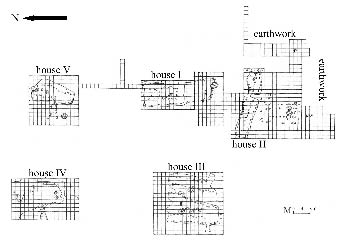
The Muradymovo settlement (Figures 4 and 7) is located on the first river terrace on the right bank of the Urshak River, 0.2 km to the east of its present course and 2.5 km north of the village of Muradymovo in the Aurgazinskiy district of Bashkortostan (Figure 3). To the west and north the settlement is delimited by a ravine (Figures 4 and 8). The settlement is situated on a hill about 1.5–2 m high and covers an area of 6 hectares (Figures 4 and 8). The WGS-84 coordinates of the settlement were recorded at five points spanning the entire area of the site (1 – N51°04’39.8, “E055°04’51.8”; 2 – N51°04’39.4, “E055°04’51.1; 3 – N51°04’39.2, “E055°04’51.3”; 4 – N51°04’39.0, “E055°04’51.0”; 5 – N51°04’39.1, “E055°04’51.4”). One part of the territory is used for pasture. Six depressions were recorded on the surface of the site with areas ranging from 260 m2 to 300 m2, and depth from 0.25 to 0.4 m (Figures 4, 7 and 8) The depressions may be divided into two groups by location: depressions I and II at the western tip of the cape, and depressions III, IV, V, VI at the eastern tip.
From north-east to the south-west the settlement is surrounded by an earthwork 1.7–3.2 m wide and 1.4–1.5 m high. We excavated an area of 672 m2, adjacent to the eastern wall of the excavation of House III (Figures 7, 9 and 10). During the excavations of an area of 202.2 m2, a farm building of 12.53×16.13 m was revealed, adjacent to House III. It is oriented, like House III, along a south-west to north-east axis and connected to the House by a covered passage, which is traced in the south-eastern part of House III. The outlines of the farm were clearly seen and the board rose 0.43–0.62 m from the mainland. From 2000 to 2003 the total excavated area of the settlement, including three houses and the space between the houses, was 2,232 m2.
R. Suleymanov (2006, 2007) conducted pedological analyses here and determined that the site was built on an ancient meadow with black alluvial soil. Upper cultural layers were characterized by a heavier granulated light and medium loam mixed with ashes. It is possible that horizons of asker were deliberately buried in clay loam to prevent deflation and erosion to insulate and fix the walls of the house (evidenced by the fact that only the southern walls of the houses were supplied with earthwork as southern winds prevail in the Southern Urals). The analysis of the cultural layer of the dwelling depression found an increase in phosphate content, indicating the anthropogenic nature of its formation.
2. Results
Five samples were selected for radiocarbon dating from within the area of the settlements: Two samples of ceramics (Figure 11) and 3 of buried soils (See table). The method of radioactive carbon analysis of ceramics was developed by the radiocarbon laboratory at the Institute of Environmental Geochemistry, NAS, Kiev, Ukraine. Various kinds of ceramics began to be widely used and distributed in Eastern Europe from the 7th to 6th centuries BC. Early pottery manufacture was closely connected with a technology, which, aside from clay components, used an organic admixture (grass, chopped straw, river and lake mud and manure) for plasticity and strength. Carbon content in the form of coal inclusions after annealing is 0.6–2% of its total weight. This carbon is relatively well protected from oxidation by an aluminosilicate matrix that makes up the bulk of ceramic material. These types of ceramics are a prerequisite for successful radiocarbon dating of many archaeological sites of the Neolithic (Obydennova et al. 2008).
3. Methodology
When dating archaeological sites from the presence of plant carbon inclusions in ceramics, special attention should be paid to the primary chemical processing of samples. An important and controversial problem to be solved is the complete removal of contaminants while maintaining the maximum possible amount of carbon inclusions. The first stage of the primary processing of ceramic fragments is the mechanical removal of the upper layer to a depth of 0.5–1 mm. The process is carried using metal brushes with the simultaneous capture of flour products in disposable collectors. The sample is then crushed into 5–10 mm fragments. This coarsely crushed sample is treated with 0.5% hydrofluoric acid in a Teflon beaker at room temperature for 2–5 hours. At the beginning and the end of processing the beaker with the reaction mixture is exposed to ultrasound for 10 minutes. This results in the destruction of the silicate-organic structure and calcium carbonate. In this case the original mineral component of ceramic samples, consisting of aluminosilicates, remains intact. Silicates, absorbed humic acids and bacterial waste products pass into the solution and do not affect the radiocarbon age.
4. Theories and reasoning
As the experience of ceramic dating has shown, bituminous substances manifest as less than 0.2% of total carbon in the samples. Bitumiol is a product of the decomposition of ancient organic compounds without oxygen. It may be present in the clay as a precipitate from the time of its inception. Its age can reach into the hundreds of thousands of years, i.e. the radiocarbon (14C isotope) is negligible. Statistical techniques can be applied to establish the presence and the degree of distortion of age due to carbon faction that can not be dates. While dating a few samples of pottery from the same cultural layer it is logical to assume that both the specific content and radiocarbon age of the bituminous substance, which was originally contained in the used clay, should be similar. At the same time the amount of organics admixed by people preparing white clay, the annealing of ready vessels and their thickness, as well as the relative mass of snuff, will inevitably lead to a wide range of variation in the proportion of the total carbon content in the samples. Samples with low total carbon content must be significantly older (due to the ancient bituminous substance) than the samples with a high total carbon content.
5. Discussion
Dating 3–7 ceramic samples from the same cultural layer and comparing the results with the specific carbon content in each we can detect the presence of confounding factors and estimate their magnitude. The utilization of a statistical approach solves a number of other important issues such as the degree of preservation of the cultural layer of a studied site, the peculiarities of its structure, and the length of its existence. In addition, we should keep in mind that ceramics can be older, but not younger than the alleged archaeological age. If younger, it is worth considering whether the pottery belongs to the dated cultural layer. It may be older, in case of high percentage of organic admixture with its own old age, as noted above.
6. Conclusion
Today the Muradymovo settlement site is one of the most completely excavated and researched in the central part of the Volgo-Urals (Usachuck et al. 2010). Radiocarbon dating of Muradymovo settlement materials showed satisfactory analytical results for ceramics, and the necessity of careful selection of soils of cultural layers for dating purposes.
Acknowledgement
We are grateful for the research assistance provided by Doctor of Science T. Leonova of the Laboratory of Methodology and Methods of Humanitarian Research of Bashkir State Pedagogical University, Ufa, and of D. Shuteleva from Ufa.
References
CHERNIKH, E. N. (Ed.) 2002: Kargaly: Gorny site – the Late Bronze settlement: Topography, lithology, stratigraphy: Household, manufacturing and sacral structures: Relative and absolute chronology V-II. Moscow.
CHERNIKH, E. N. (Ed.) 2004: Kargaly: Gorny site: Archaeological materials: Technology of mining and metallurgy: Archaeobiological studies V-III. Moscow.
GOLYEVA, A. A. 2008: Microbiomorphic Analysis as Tool for Natural and Anthropogenic Landscape Investigations: Genesis, Geography, Information. First ed. Institute of geography Russian Academy of Science, Moscow.
GOLYEVA, A. A., KHOHLOVA, O. S., OBYDENNOVA, G. T., SHUTELEVA, I. A., SHERBAKOV, N. B. 2010: Economic and household specificity of settlement of bronze age Muradymovo (Bashkiria) according to soil researches, Materials of 18th Ural Archaeological Meeting.
HANKS, B. K., EPIMAKHOV, A.V., RENFREW, A. C. 2007: Towards a Refined Chronology for the Bronze Age of the Southern Urals, Russia. Antiquity Vol. 81, Num. 312, 353–367.
SHUTELEVA, I., SHERBAKOV, N., GORSHKOV, K. 2010: The Archaeological Study of Kazburun Barrow Burial Ground: Initial Results. Reports. The European Archaeologist, Issue no. 34: Winter, 21–23.
OBYDENNOVA, G. T., SHERBAKOV, N. B., SHUTELEVA, I. A., KHOHLOVA, O. S., KOVALJUH, N. N., SKRIPKIN, V. V. 2008: Some results of application of the complex approach at studying a monument of a late bronze age Bashkir Priuraljy – settlements Muradymovskogo. In: Works of II (XVIII) All-Russia archeologic congress in Suzdal. Moscow, 435 – 438).
USACHUCK, A. N., OBYDENNOVA, G. T., SHUTELEVA, I. A., SHERBAKOV, N. B. 2010: Microware analysis and functional-typological analysis of a collection of bone artifacts from the excavation of the 9th settlement in Muradymovo (season 2007, Republic Bashkortostan), Materials of the 18th Ural Archaeological Meeting.
*Corresponding author. E-mail: sherbakov@rambler.ru
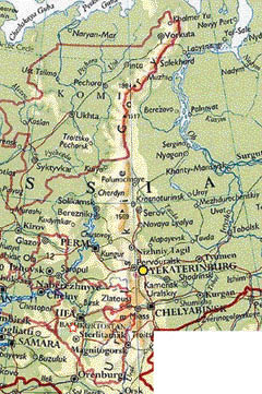
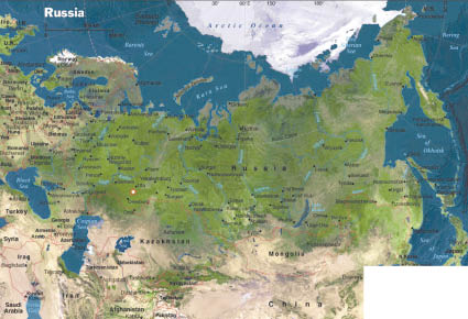
Figure 1. Map Volgo-Urals area with location of Muradymovo settlement. Map of Eurasia indicating Southern Ural Mountain, location Muradymovo settlement and other settlements of the late Bronze Age.
Figure 2. Map Russia with location of Muradymovo settlement. Map of the Volgo-Urals region indicating areas of the Srubnay and the Alakul’s cultures.
Figure 3. Aerial photography of Muradymovo settlement. Aerial photography (1963) describes landscape of Muradymovo settlements.
Figure 4. 3D-reconsruction landscape of Muradymovo settlement, by Golden Surfer 9.0.
Figure 5. Location settlements of the Late Bronze Age Volgo-Urals (r. Djema – r. Urshak). Map of the Djema – Urshak region The Srubnay and the Alakul’s cultures come into contact between the Djema and the Urshak rivers dense population is typical for this region in the Late Bronze Age and sites and structure of them are similar.
Figure 6. Calibrated date of Muradymovo settlement for decoration pots (Srubno-Alakul’ culture); rectangle indicates key period 1750–1350 BC. Calibration by OxCal 3.10.01.
Figure 7. Muradymovo settlement. Plan of the settlement area with excavated parts of the site (1995–2010).
Figure 8. Topoplan of Muradymovo settlement, by Golden Surfer 9.0.
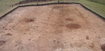
Figure 9. House III of Muradymovo settlement (excavation 2000–2007)
Figure 10. House IV of Muradymovo settlement (excavation 2006–2010).
Figure 11. Pots of Muradymovo settlement. Decoration pots (Srubno-Alakul’ culture) of Muradymovo settlement for radiocarbon dating in the radiocarbon laboratory of the Institute of Environmental Geochemistry, National Academy of Science (NAS) of Ukraine, Kiev (N. Kovaluh, V. Skripkin, 2008).
Muradymovo settlement
Muradymovo settlement


0 10 cm
0 10 cm